
Pricing Change
New pricing for orders of material from this site will come into place shortly. Charges for supply of digital images, digitisation on demand, prints and licensing will be altered.
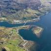
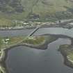
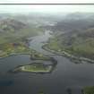
Dornie


Village (19th Century)
Site Name Dornie
Classification Village (19th Century)
Alternative Name(s) Loch Long; Loch Duich
Canmore ID 11820
Site Number NG82NE 27
NGR NG 882 264
NGR Description Centred NG 882 264
Datum OSGB36 - NGR
Permalink http://canmore.org.uk/site/11820


- Council Highland
- Parish Kintail
- Former Region Highland
- Former District Skye And Lochalsh
- Former County Ross And Cromarty
Dornie
One of the Earl of Seaforth's planned fishing and trading stations, Dornie was established at the mouth of Loch Long, where sweet grazings for black cattle and a rich supply of herring from Loch Duich offered great promise. Plans were drawn up by David Urquhart in 1794, and in 1801 William Cumming surveyed it for the new proprietor, Sir Hugh Innes. By 1812 , the population amounted to some four or five hundred persons: it was a 'thriving town or village [exceeding] in most respects, any of the villages settled or fostered by the British [Fisheries] Society ', and in the mid-19th century sailing ships of up to 200 tons were built here. But Dornie did not remain a thriving centre of trade, and suffered with the decline of the fishing. It remained an important ferry crossing until a ferroconcrete bridge was built in the 1940s, replaced in 1990 by Sir William Fairhurst & Partners' present bridge. Dornie's principal feature today is long, onesided Francis Street (c.1800 and later), neatly strung out to catch the sun across the Loch. The plain, whitewashed or brightly coloured houses are very much in the Telford idiom. Mission Church (now church hall) on Carr Brae, Ross & Macbeth, 1889, a spireletted twin of the Free Church at Stromeferry. St. Duthuc's Church (RC) and Presbytery, Joseph Hansom, 1871, well-grouped but somewhat gloomycoloured complex with simple gothic detail, built with funds from the Duchess of Leeds. In William Street, Robert Hurd & Prtnrs' housing association development of 1983 demonstrates this firm's understanding of West Highland housing traditions. Their crescent of harled and slated houses complements the earlier group on the left with all too rare sensitivity.
[In about 1890, A. C. Mackenzie wrote of Dornie: 'The village was at one time a considerable centre of trade for the district, and contained the only shops in these parishes; but the business fell off as shops were opened in other townships ... The only flourishing industry now is shoemaking'.]
Taken from "Western Seaboard: An Illustrated Architectural Guide", by Mary Miers, 2008. Published by the Rutland Press http://www.rias.org.uk

NG82NE 27 centred 882 264.
".. fishing village..
The Imperial Gazetteer of Scotland, 206
"..a small fishing village on the E side of Loch Long..the houses are chiefly two stories high and slated. They are in good repair.."
Name Book 1880, ref no. 19, 113
Forty-five roofed, one partially roofed and two unroofed buildings are depicted on the 1st edition of the OS 6-inch map (Ross-shire 1880, sheet cxxiii). Thirty-three roofed buildings are shown on the current edition of the OS 1:10000 map (1972).
Information from RCAHMS (SAH) 7 May 1996

