
Caisteal Grugaig


Broch (Iron Age)
Site Name Caisteal Grugaig
Classification Broch (Iron Age)
Alternative Name(s) Dun Totaig
Canmore ID 11812
Site Number NG82NE 2
NGR NG 8668 2508
Datum OSGB36 - NGR
Permalink http://canmore.org.uk/site/11812


First 100 images shown. See the Collections panel (below) for a link to all digital images.
- Council Highland
- Parish Glenshiel
- Former Region Highland
- Former District Skye And Lochalsh
- Former County Ross And Cromarty
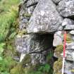
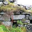
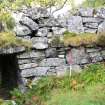
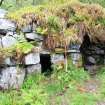
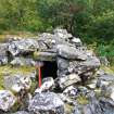
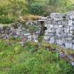
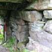
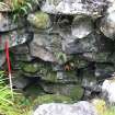
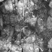
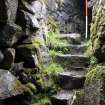
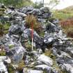
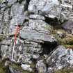
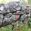
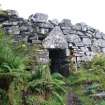
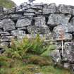
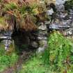
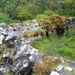
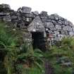
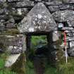
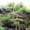
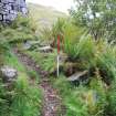
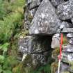
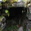
Caisteal Grugaig, late 1st millennium bc. Truncated cone of a broch hidden in forestry above a burn, its huge masonry slabs beautifully coursed in a great ferny ring. Steps lead up to an entrance passage (still with bar holes), approached under a massive, pediment shaped lintel. The guard's chamber, and a portion of the mural stairway and cells, are still evident. Excavated/cleared out 1889.
Taken from "Western Seaboard: An Illustrated Architectural Guide", by Mary Miers, 2008. Published by the Rutland Press http://www.rias.org.uk

NG82NE 2 8669 2508
(NG 8669 2508) Caisteal Grugaig (NAT)
Supposed Remains of Pictish Tower (NR)
OS map [no date cited].
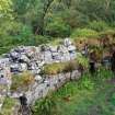
A well-preserved broch standing to a maximun height of 13' and clearly exemplifying several broch features - e.g. door check, mural chambers, and remains of stair and gallery.
The natural floor is on a slope, so that the scarcement, which is level, lies at heights varying between 2'4" and 7' above it. The lintel above the outer end of the entrance passage is triangular. It was cleared out in 1889. (T Wallace 1897)
R W Feachem 1963; A Graham 1951; T Wallace 1897.
'Caisteal Grugaig', a broch as described and planned above. The name is still known locally.
Surveyed at 1:10,000.
Visited by OS (N K B) 27 September 1966.
"Broch to the west of Totaig, Loch Duich, Trench cut by T C Lethbridge in 1924 in interior revealed" no stones & very few finds inside, 4" humus, 2" black soil with nothing in it (? fallen roof thatch), undisturbed rock subsoil.
Information contained in letter from T C Lethbridge (on back of photograph A54141/po from MS/228) to OS 21 January 1951.
Publication Account (1995)
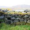
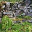
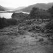
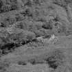
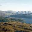
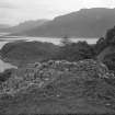
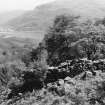
The broch stands on the hillside overlooking the junction of Loch Alsh, Loch Duich and Loch Long, a view now partially obscured by forestry plantations. It is built of substantial stones giving a particularly solid appearance, and much of the outside wall stands clear of debris.
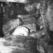
The interior was cleared out in 1899, so many structural features are visible despite its ruined state. The floor inside is the natural surface of a rocky knoll and is very irregular, dropping some 1.50m from southwest to northeast. The entrance is at the lowest point, and has a fine triangular lintel, one set of door checks, a bar-hole to the right and a guard chamber, now blocked, on the left. Further round the wall on the inside a small doorway opens into a round cell with high corbelled roof. Next to this, a larger doorway leads to a short flight of stairs, rising to a level passage, now partly blocked by tumble. From this passage a doorway opens onto the scarcement ledge, while beyond it the stairs once continued upwards. The high doorway is an interesting feature, probably once common in many brochs, but not often preserved, though there is another at Rhiroy (no. 86). It led out onto a wooden floor supported by the scarcement ledge, here less than a metre above the ground. On the opposite side of the broch yet another door opened into two long cells running right and left within the wall, both now blocked by tumble, but partly visible amid the rubble of the walls. Such long cells may have been used, like souterrains, as cool stores.
On the way back, look for bait holes in the rocks. These are east of the Totaig slipway, at the first corner in the road, on rocks under a tree above the shore. They were used for crag fishing, when shellfish such as limpets were pounded up in the holes and thrown into the water to attract fish into frame nets.
Information from ‘Exploring Scotland’s Heritage: The Highlands’, (1995).
Publication Account (2007)
NG82 1 CAISTEAL GRUGAIG ('Castle Grugag')
NG/8669 2508
This well preserved transitional (partly ground-galleried) broch in Loch Alsh, Ross and Cromarty, stands on a small rocky knoll on a grassy slope; it was cleared of debris in 1889 (“I had the privilege of seeing this broch cleared out in 1889, and can give the following particulars of the ruins as they now stand.” [2, 86])but no detailed record of the excavation seems to have survived. This is the fourth of the major, well preserved sites on the coast of western Inverness-shire, near Glenelg, and is the least well known. The 18th century visitors who came to the area were evidently not told about it, presumably because it is much further than an easy walk or ride from the army barracks and had not been discovered by the military. No doubt also it was nothing but a huge heap of stones at that time.
The rock surface which forms the floor of the central court rises 1.5m (5 ft) from one side to the other, and this has resulted in some unusual architectural features which enlighten us about the interior furnishings of brochs. Graham [4] provides a number of useful photographs of these.
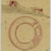
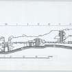
1. Description
Level 1. The outer face of the broch is slightly battered and is constructed of large blocks of stone; the quality of the masonry is inferior to that of Dun Troddan and Dun Telve, a fewmiles to the south. The lowest level is, as usual, defined as that part below scarcement level although, as in the case of Dun Grugaig 1 (NG81 1), the thickness of Level 1 varies because of the uneven-ness of the underlying rock. The segment between about 10 and 2 o'clock seems to be solid, although quite low because of the height of the rock. Elsewhere there are galleries, cells, the entrance passage and the stair.
The well preserved main entrance is at the lowest point of the slope and faces north-east and has a large triangular lintel bridging the outer end. The passage is 1.45m (4 ft 9 in) high and 92cm (3 ft) wide at the exterior; the door-frame is about 1.32m (4 ft 4 in) from the outside [2]. The door-checks are made of large blocks including upright facing slabs at the base. The passage widens to 1.17m (3 ft 10 in) behind the door-frame and a bar-hole, over 1.95m (6.5 ft) deep, is behind the right check; the opposed socket is not mentioned anywhere and may not be preserved.
The door-frame of this broch has an unusual feature; the lintels in front of the door checks are lower than those behind, the rear edge of the one immediately over the door-frame being flush with the checks. Thus there is effectively a check in the roof as well. The lintel behind this forms another step up, presumably to compensate for the upward slope of the passage floor; the rest are on the same level. Exactly the same arrangement is to be seen in the broch at Torwood, Stirlingshire (NS88 1). The inner end of the passage has converging jambs [4, pl. Vc].
An elongated guard cell, 4.22m (13 ft 10 in) in length and 1.53m (5 ft) wide, opens off the left wall of the passage through a narrow, low doorway. Its roof is now badly ruined but an elevation of this part of the wall drawn by Sir H Dryden in the later 19th century shows it rising to a beehive dome and the author’s photograph of the lower part of the dome tends to confirm this. This is rather a strange arrangement if a Level 2 gallery communicated with the chamber over the entrance (below). Notes on the back of the author’s photograph of the interior of this cell specifically state that there is a stairway in it which rises over the small cell at 8.30 o’clock – but this is not mentioned by Graham .
At about 8.30 o'clock in the inner wallface is the door to a small, oval mural cell measuring 2.09m (6 ft 10 in) by 1.37m (4.5 ft); its door is 46cm (1.5 ft) wide and 94cm (3 ft 1 in) high and there is an aumbry (or cupboard) in its wall. The cell is slightly corbelled and then roofed with flat lintels some of which can still be seen in position immediately behind the doorway; as in the main entrance the lintel of the doorway is lower than those behind.
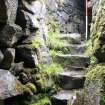
Immediately south of this, at 9 o'clock, is the doorway to the mural stair 1.45m (4 ft 9 in) high [4] and the rock threshold of which is only about 1.22m (4 ft) below the scarcement; the lintel is correspondingly about 92cm (3 ft) above the scarcement, an unusual arrangement. There is now no trace in the dilapidated masonry of a void above this doorway. The reason for this interruption to the scarcement is clearly because of the high level of the rock at this point and the need to make the stair door reasonably high. The means by which the ledge passed over the doorway is described below (Level 2).
The five steps of the stair rise 1.09m (3 ft 7 in) to the right and lead up to a long landing (below); there is no stair-foot guard cell. Because of the higher level of the rock surface under this uphill part of the broch wall the segment of the wall base here – from 9.30 o'clock (under the first flight of steps) to 2 o'clock – is relatively low and appears to be solid. This explains why there is a clearly built end to the next long segment of ground level gallery clockwise from this point (below).
At 3 o'clock is the blocked door – 92cm (3 ft) high and 76cm (2 ft 6 in) wide – to another long mural cell, or length of ground gallery, 10.68m (35 ft) long and apparently built directly on the rock. Most of this gallery is also blocked with stone debris but there is a gap in its roof of flat lintels – forming the floor of the first floor gallery (below) – through which the curved left end can be seen some 3.36m (11 ft) west of the doorway [4, 16]. Sir Henry Dryden's plan shows the other curved end 2.44m (8 ft) south of the cell door, so the total length should be about 10.68m (35 ft). The door to this long cell or gallery has its lintel below scarcement level and there are no signs of a void above it.
Level 2 is as usual defined as beginning at scarcement level. The sides of a chamber are apparent above the entrance passage, its floor being formed from the lintels of that passage; it has a curved outer end, behind the triangular lintel. The main opening into this chamber is through the inner wallface where the innermost passage lintel forms the sill of a large, door-sized opening and is also part of the scarcement. According to Graham [4, 17], in 1924 Watson saw the junction between this chamber and the stretch of first floor gallery running clockwise from the entrance (this was presumably blocked by the corbelled roofing of the guard cell and the mural cell). The photograph reproduced here may show this junction but the masonry is now ruinous.
The scarcement itself is 31cm (12 in) wide, partly corbelled and partly of the ledge type. It is more or less horizontal and, since the rock floor of the central court varies in level over a vertical distance of 1.53m (5 ft), the height of the ledge above it ranges from 2.14m (7 ft) immediately east of the entrance to 71cm (2 ft 4 in) from 10 - 11 o'clock. Between 9 and 10 o’clock however the ledge rises up, and then descends to the original level, in a series of shallow steps in order to override the two adjacent doorways there. This is a unique feature in broch scarcements so far as is known at present.
There appears to have been a first floor, intra-mural gallery running most or all of the way round the wall – interrupted as usual only by the stairway and perhaps on one side by the chamber over the entrance – and with its mainly lintelled floor at about scarcement level. However if the guard cell had a corbelled roof this Level 2 gallery would have been interrupted there as well; the small cell at 8.30 o'clock seems to have a flat, lintelled roof.
Running clockwise from the main entrance there are traces of the gallery on the wallhead, filled with rubble, with one or two lintels in position; the wallhead at 9 o'clock stands about 1.53m (5 ft) above the scarcement.
A landing, about 4.27m (14 ft) long, runs from the top of the first flight of steps at 9.30 o'clock to the beginning of the second flight at almost 12 o'clock. This landing forms the floor of an empty section of the upper gallery, still with its lintelled roof in position about 2.4m (8 ft) above the floor, and the walls of which are smooth and neatly built. The wallhead at 12 o'clock is still about 4.0m (13 ft) high and the inner face overhangs here for about 23cm (9 in) inwards; it is possible that there was an upper scarcement here a little higher up. After about 7.02m (23 ft) this raised gallery reaches a tall, lintelled void or doorway in the inner wallface, 2.44m (8 ft) high and 61cm (2 ft) wide, and two steps lead down to its scarcement level sill from the gallery floor.
In 1924 Watson saw nine steps of a further flight just beyond this void which led to an even higher gallery but in 1948 these were obscured by debris [4, 17]; however it is still possible to see the underside of the steps. Beyond this the wallhead rapidly becomes lower but there are more traces on it of the Level 2 gallery; this section must have been inaccessible, being blocked at one end by the second flight of stairs and at the other by the presumably solid side wall of the chamber over the entrance. There are no signs of any voids in the inner wallface in this north-west arc of the wall.
Level 3: since the tall first floor gallery containing the landing has a lintelled roof it seems that there must have been at least one more gallery all the way round the wall. The second flight of intra-mural stairs at 12 o'clock must have given access to this upper level and either used part of it as a second landing or blocked it off and gone straight up to a Level 4 gallery. As noted the lintels forming the floor of this upper gallery are visible above the first stairway.
2. Discussion
There are several interesting architectural features in Caisteal Grugaig. In the first place it contrasts sharply with the neighbouring Dun Troddan and Dun Telve in not being solid-based, not being built on flat ground and in lacking the high standard of skill in drystone masonry shown in the smooth profiles and neatly underpinned blocks of the two Glenelg brochs. It is also another example of the increasing number of brochs and semibrochs (so far all in the west – see footnote) known to have been built on such uneven ground that special arrangements had to be made by the builders to keep the galleries level. The other sites on uneven ground include the three semibrochs Dun an Ruigh Ruaidh (NH19 2), Dun Ardtreck (NG33 2) and Dun Grugaig 2, Glenelg (NG811) and also Dun Borodale broch on Raasay (NG53 2). Here the basal part of the wall (Level 1) had to be shallow and solid on the uphill side, and the cells and the entrance passage are all in the arc from north-west to south-east. If the original upper levels and wallhead were horizontal all the way round, which seems highly likely, the downhill wall must have been 1.53m (5 ft) or more higher than the uphill one.
Graham was the first to draw attention to the significance of the variation in the height of the level scarcement above the sloping rock floor of the central court [4, 17-19]. That the idea that the scarcement supported the main roof of this broch – argued for in general by Scott (1947) – is wholly implausible here is shown by its being only 71cm (2 ft 4 in) above the floor on the uphill side. Here, as at the other sites mentioned, it seems quite clear that the scarcement supported a raised, level wooden floor or balcony and that the main roof was higher up. There may even be a trace of the upper scarcement here on the inner wallface on the uphill side.
Moreover at this site it is exceptionally clear how this wooden balcony was reached by way of the intra-mural stone stair and the first landing. This led to the tall raised void or doorway at 12 o'clock which, the landing being slightly above scarcement level, was equipped with two stone steps leading down to the ledge. Also such an annular wooden floor would have given easy access to any other raised doorways in the inner wallface, such as the chamber over the entrance the sill of which forms part of the scarcement.
The curious arrangement at 10 - 11 o'clock – where the scarcement is interrupted by the stair door and rises up over it as a shallowly ascending and descending ledge of projecting stones – also in fact supports the hypothesis of a stone support for a level wooden floor even though, at first sight, itmight seem to count against it. The need to have the scarcement at the level of the floor of the chamber above the entrance evidently dictated its height on the opposite side of the court where – if it was to be level – it would have cut through the stair door. Thus at this site we have the only known occasion of an interrupted scarcement which, as Graham says, probably supported a form of gangway or shallow flight of wooden steps rising over the door.
Finds
In the National Museum is a fine, decorated handled stone cup of steatite, presumably imported, from this site (AQ 116). Half of a quern, presumably rotary, was found in the broch during clearance [2, 87].
Dimensions
According to Graham [4] the external diameter of the structure is 16.50 - 16.78m (54 - 55 ft), the internal one is 9.61m (31.5 ft); the walls thus occupy 42.2% of the total diameter and vary in thickness from 3.50m (11 ft 5 in) to 3.74m (12 ft 3 in). In 1971 a fresh survey of the central court, undertaken with a theodolite and steel tape, showed that in plan it is almost an exact circle with a radius of 4.69 +/- 0.06m; this gives a diameter of 9.38m (30 ft 9 in).
Sources: 1. NMRS site no. NG 82 NE 2: 2. Wallace 1897: 3. Watson 1924: 4. Graham 1949, 14-19, fig. 3 and pls. IV-VI: 5. Young 1962, 189: 6. Feachem 1963, 170: 7. MacKie 1975, 160: 8. MacKie 2000 9. Close-Brooks 1986, 148-49: 10. Armit 2003, 66.
E W MacKie 2007
Laser Scanning (6 October 2010)
NG 8669 2508 A laser scan survey was carried out on the 6 October 2010 at the well preserved broch site of Caisteal Grugaig by AOC Archaeology on behalf of Forestry Commission Scotland. Stone-by-stone drawings and a range of orthographic images of the site were also produced. The archaeological survey was undertaken using a Trimble FX laser scanner, and a detailed descriptive report and photographic record was compiled.
Archive: RCAHMS (intended)
Funder: Forestry Commission Scotland
OASIS ID: aocarcha1-86792
Project code: AOC 21713
Conservation (20 January 2018 - 25 March 2018)
NG 8669 2508 A programme of conservation work was undertaken, 20 January – 25 March 2018, at the broch. This involved the consolidation of displaced stones within the walls and on the wall head, and the stabilisation of weakened load-bearing elements such as lintels spanning passageways. The work, undertaken by stonemasons, was monitored and recorded by an archaeologist. The recording consisted of a before and after conservation laser scan survey, using a Trimble TX5 laser scanner, and production of a written and photographic record.
Archive: NRHE (intended)
Funder: Forestry Commission Scotland
Jamie Humble – AOC Archaeology Group
(Source: DES Volume 19)

