Pricing Change
New pricing for orders of material from this site will come into place shortly. Charges for supply of digital images, digitisation on demand, prints and licensing will be altered.
Upcoming Maintenance
Please be advised that this website will undergo scheduled maintenance on the following dates:
Thursday, 9 January: 11:00 AM - 3:00 PM
Thursday, 23 January: 11:00 AM - 3:00 PM
Thursday, 30 January: 11:00 AM - 3:00 PM
During these times, some functionality such as image purchasing may be temporarily unavailable. We apologise for any inconvenience this may cause.
Eigg, Bidein An Tighearna
Enclosure (Post Medieval), Mound (Post Medieval), Peat Cutting (Post Medieval), Pen (Post Medieval), Shieling Hut(S) (Post Medieval)
Site Name Eigg, Bidein An Tighearna
Classification Enclosure (Post Medieval), Mound (Post Medieval), Peat Cutting (Post Medieval), Pen (Post Medieval), Shieling Hut(S) (Post Medieval)
Canmore ID 118027
Site Number NM48NE 43
NGR NM 4839 8839
Datum OSGB36 - NGR
Permalink http://canmore.org.uk/site/118027
- Council Highland
- Parish Small Isles
- Former Region Highland
- Former District Lochaber
- Former County Inverness-shire
Field Visit (28 August 2001)
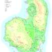
This group of 13 shieling huts, in addition to a mound, an enclosure and a pen, is situated on the high ground about 600m SE of Cleadale to either side of the Allt Bidein an Tighearna. The huts are spread out over an area measuring 180m from NW to SE by about 90m transversely. Further huts can be found 140m to the NE (see NM48NE 138) and 50m to the SW (see NM48NE 140).
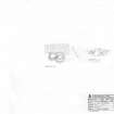
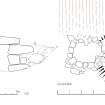
Ten of the huts (634-6, 638-44, 775) have two compartments linked by a low creep giving the appearance of a figure-of-eight on plan. Most are built of drystone and turf, but in one example (637) erosion has reduced the remains to an indistinct mound. The best preserved (641) stands on the N side of the burn at the SE edge of the group (NM 48491 88339). It consists of two adjoining cells linked by a low lintelled creep. The larger NW cell measures 2.3m from NW to SE by 1.8m transversely, within a rubble wall 0.6m thick and 0.8m high. There is an entrance on the NW. The SE cell measures only 1.5m from NW to SE by 1.4m transversely, but its rubble walls are embanked with turf giving an overall thickness of 1.5m. A twinning pen for lambs has been constructed by one of the huts (635).
At the narrow mouth of the gully to the NW of the shielings is an enclosure (867) measuring 14m from NW to SE by 13m transversely, formed by two stout drystone walls. This is depicted on the 1st edition of the OS 6-inch map (Inverness-shire (Skye), Sheet LXXI, 1879).
There are traces of peat cutting on the valley floor.
EIGG01 633-644, 775, 866-867
Visited by RCAHMS (AGCH) 28 August 2001
Measured Survey (24 April 2002)
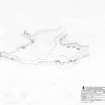
RCAHMS surveyed the shieling group at Bidein An Tighearna on 24 April 2002 with plane table and self-reducing alidade at a scale of 1:500. The plan was later used as the basis of an illustration published in 2016 (Hunter, fig. 3.49).
Measured Survey (24 April 2002)
RCAHMS surveyed the shieling group at Bidein An Tighearna on 24 April 2002 with plane table and self-reducing alidade at a scale of 1:500. The plan was later used as the basis of an illustration published in 2016 (Hunter, fig. 3.49).
Note
An enclosure is depicted on the 1st edition of the OS 6-inch map (Argyllshire & Inverness-shire, Islands of Rum and Eigg 1879, sheet lxxi). One enclosure and what may be six unroofed shieling-huts are shown on the current edition of the OS 1:10000 map (1976).
Information from RCAHMS (AKK) 9 December 1996.


