
Pricing Change
New pricing for orders of material from this site will come into place shortly. Charges for supply of digital images, digitisation on demand, prints and licensing will be altered.
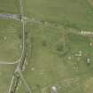
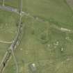
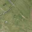
Tain Airfield, No. 2 Dispersal Site


Air Raid Shelter(S) (20th Century), Bomb Store (20th Century), Building(S) (20th Century), Dispersal Bay(S) (20th Century), Firing Range (20th Century)
Site Name Tain Airfield, No. 2 Dispersal Site
Classification Air Raid Shelter(S) (20th Century), Bomb Store (20th Century), Building(S) (20th Century), Dispersal Bay(S) (20th Century), Firing Range (20th Century)
Alternative Name(s) No.2 Dispersal Site; Fendom
Canmore ID 117571
Site Number NH88SW 14.11
NGR NH 8310 8250
NGR Description Centred NH 8310 8250
Datum OSGB36 - NGR
Permalink http://canmore.org.uk/site/117571


- Council Highland
- Parish Tain
- Former Region Highland
- Former District Ross And Cromarty
- Former County Ross And Cromarty
NH88SW 14.11 Centred 8310 8250
Situated to the E of the end of the N-S runway of Tain airfield, No.2 dispersal site with several ancillary buildings. Of note is the bomb store and a large brick built wall used as a standard wartime weapon machine gun 25 yard range (type 147/41). Other structures include two different types of air-raid shelter and various concrete buildings.
Visited by RCAHMS (DE) May 1997

