
Tain Airfield, No.4 Dispersal Site


Building(S) (20th Century)
Site Name Tain Airfield, No.4 Dispersal Site
Classification Building(S) (20th Century)
Canmore ID 117567
Site Number NH88SW 14.09
NGR NH 82489 81917
Datum OSGB36 - NGR
Permalink http://canmore.org.uk/site/117567


- Council Highland
- Parish Tain
- Former Region Highland
- Former District Ross And Cromarty
- Former County Ross And Cromarty
NH88SW 14.09 82489 81917
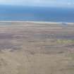
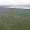
Situated some 500m NW of the airfield control tower (NH88SW 14.05) immediately N of the public road leading to the bombing range is a small group of wooden buildings. The group consists of three rows of huts joined in a half H shape with one further hut to the NE. A fuel tank lies in the central area and all the buildings are surrounded by what appears to be an original white painted fence.
The buildings lie in an area originally part of Tain airfield, known as No.4 dispersal site (RAF archive 77/1/1413) and the RAF (Archive) plan annotates them as the original Tain bombing range buildings.
Visited by RCAHMS (DE) May 1997

