
Pricing Change
New pricing for orders of material from this site will come into place shortly. Charges for supply of digital images, digitisation on demand, prints and licensing will be altered.
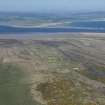
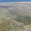
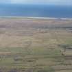
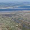
Tain Airfield, Bombing Range


Building(S) (20th Century), Control Tower(S) (20th Century)
Site Name Tain Airfield, Bombing Range
Classification Building(S) (20th Century), Control Tower(S) (20th Century)
Alternative Name(s) Morrich More
Canmore ID 117566
Site Number NH88SW 14.08
NGR NH 8373 8330
NGR Description NH 8373 8330 and NH 8390 8340
Datum OSGB36 - NGR
Permalink http://canmore.org.uk/site/117566


- Council Highland
- Parish Tain
- Former Region Highland
- Former District Ross And Cromarty
- Former County Ross And Cromarty
NH88SW 14.08 8373 8330 and 8390 8340
The control tower for Tain Bombing Range (NH88SW 14.01) is situated immediately to the SE of the tracked target range (NH88SW 14.02). It is of steel and concrete construction with ancillary buildings consisting of offices and garages to the SW. The previous control tower stood at NH 8373 8330, this being built in trestle style, of wood. The tower in its original form, supported a radar aerial and was much taller than when in use as a control tower for the bombing range. This tower survived until c1992, when it was demolished when the new tower was brought into service.
Information from RCAHMS (DE) May 1997

