
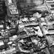
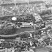
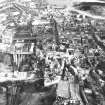
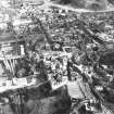
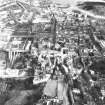
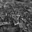
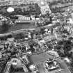
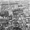
Edinburgh, Johnston Terrace, General


General View (Period Unassigned)
Site Name Edinburgh, Johnston Terrace, General
Classification General View (Period Unassigned)
Canmore ID 117521
Site Number NT27SE 1365
NGR NT 25266 73414
NGR Description Centred NT 2526 7341
Datum OSGB36 - NGR
Permalink http://canmore.org.uk/site/117521


- Council Edinburgh, City Of
- Parish Edinburgh (Edinburgh, City Of)
- Former Region Lothian
- Former District City Of Edinburgh
- Former County Midlothian
NT27SE 1365 centred 2526 7341
See also George IV Bridge (for 1827 Hamilton Scheme).
REFERENCE:
Edinburgh Public Library:
Alex. Skene of Rubislaw - drawing of construction.
(Undated) information in NMRS.
Watching Brief (2 December 2013 - 4 December 2013)
NT 2511 7339 A watching brief was carried out, 2–4 December 2013, during the excavation of two trenches in advance of the installation of a new rock fall barrier on the N side of Johnston Terrace. There were no finds or features of archaeological significance.
Archive: RCAHMS (intended)
Funder: Historic Scotland
Alan Radley - Kirkdale Archaeology
(Source: DES)
Watching Brief (28 October 2015 - 1 March 2016)
NT 2514 7338 (centred on) A watching brief was maintained, 28 October 2015 – 1 March 2016, immediately below the S side of Edinburgh Castle, during path relocation work on the N side of the road. At Johnston Terrace’s SW end, where the present work was concentrated, it skirts the base of the cliffs that form this side of the rock, while further to the NE it runs across the slope below the esplanade. Earlier work had shown that well preserved deposits predating Johnston Terrace’s construction survived along its SE side at the NE end. This was thought to be at least partly because the NW (upslope) side was quarried into the slope, with the material removed from here spread to the SE to provide a level terrace for the road, sealing earlier deposits.
No evidence of natural in situ deposits were recorded in any of the monitored areas, with even the deepest areas of excavation, to 1.10m, containing only evidence of deposits of anthropogenic origin. This is almost certainly a testament to the immense amount of landscaping that the construction of Johnston Terrace involved. The SW end of the road feeds onto a substantial bridge crossing King’s Stables Road, with clear
evidence of the creation of a substantial bank connecting the lower end of Johnston Terrace to this bridge. Indeed, the regularity and coincidence of positioning of the whole slope below the lower end of Johnston Terrace suggests that this is all artificial, relating to the road’s construction.
Archive: NRHE (intended)
Funder: Historic Environment Scotland
Gordon Ewart – Kirkdale Archaeology
(Source: DES, Volume 17)

