
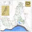
Badentarbat


Building(S) (Medieval) - (Post Medieval), Outbuilding (19th Century) - (20th Century), Quarry (19th Century), Round Ended Building (Medieval) - (Post Medieval)
Site Name Badentarbat
Classification Building(S) (Medieval) - (Post Medieval), Outbuilding (19th Century) - (20th Century), Quarry (19th Century), Round Ended Building (Medieval) - (Post Medieval)
Canmore ID 116618
Site Number NC01SW 24.04
NGR NC 0139 0999
Datum OSGB36 - NGR
Permalink http://canmore.org.uk/site/116618


- Council Highland
- Parish Lochbroom
- Former Region Highland
- Former District Ross And Cromarty
- Former County Ross And Cromarty
Field Visit (9 August 1994)
NC01SW 24.04 0139 0999
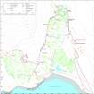
In heather moorland to the SSE of Badentarbat House, between the track leading to the house and the head-dyke of Badentarbat township, there are three buildings which may, like the round-ended building (NC01SW 24.03) 600m to the NW, be of medieval date. A fourth structure built in an abandoned quarry to the NE of this group is probably the remains of an outhouse of relatively recent date.
The most southerly of the three buildings is situated at NC 0141 0996 (ACHIL94 425). Aligned ENE-WSW, it measures 9.1m in length by 3m in breadth within walls reduced to stony banks 0.4m in height and spread to 1.5m in thickness. It has rounded ends and an entrance towards the WSW end of the NNW side wall, opening into the lower of the two compartments, the interior of which has been divided. About 30m to the NNW there is a smaller building, measuring 7m in length from NE to SW by 4.2m in
breadth over turf walls spread to 1.2m in thickness. The sides of this building are bowed but the ends have been destroyed (ACHIL94 426; NC 0139 0999). The third building is 40m NW of the second (ACHIL94 434 at NC 0136 1002). Subrectangular in shape, and slightly wider at its SSW end, it measures 7.2m NNE-SSW by 3.1m within a turf-and-stone wall 0.7m
thick. These buildings are all unlike the more regularly rectangular structures that predominate in the township (NC01SW 24.01); that and their poor condition, turfed over in heather moorland, would seem to suggest an early date, although it should be noted that May's 1758 survey depicts a solitary building at approximately this location (SRO, RHP 85395).
To the ENE of the third building, on the NE side of the track, there are the remains of a fourth structure, probably an outhouse, set into an abandoned quarry. It has measured 5.3m in length by 3m in breadth within faced-rubble walls which survive to a height of 1.2m on the NW, where they have been built against the side of the quarry. There is a small outshot, 3.2m square, at the NE end (ACHIL94 486; NC 0141 1005). The quarry may have been used to provide stone for the track, which is likely to be contemporary with the present (19th century) house; if so, this structure can be of no great age.
(ACHIL94 425-6, 434, 486)
Visited by RCAHMS (SDB) 9 August 1994

