
Badentarbat


Bank (Earthwork)(S) (Prehistoric) - (Post Medieval), Cairnfield (Prehistoric), Hut Circle(S) (Prehistoric), Lynchet(S) (Prehistoric) - (Post Medieval)
Site Name Badentarbat
Classification Bank (Earthwork)(S) (Prehistoric) - (Post Medieval), Cairnfield (Prehistoric), Hut Circle(S) (Prehistoric), Lynchet(S) (Prehistoric) - (Post Medieval)
Canmore ID 116599
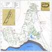
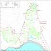
Site Number NC01SW 24.02
NGR NC 0094 1035
Datum OSGB36 - NGR
Permalink http://canmore.org.uk/site/116599


- Council Highland
- Parish Lochbroom
- Former Region Highland
- Former District Ross And Cromarty
- Former County Ross And Cromarty
Field Visit (8 August 1994)
NC01SW 24.02 0094 1035
At the NW edge of Badentarbat township there are three hut-circles, a scatter of small cairns, short lengths of lynchet and stretches of bank on an E-facing hillside now covered with heather and bracken. One hut-circle lies within the township head-dyke (ACHIL94 414; NC 0100 1031). The ESE half of this hut has been robbed out, and lazy-beds overlie the line of the wall on that side, but the WNW half survives, set into the hillside and measuring 8.2m NNE-SSW within a stony bank spread to 2.1m in thickness. Part of the inner face survives on the SW. The second hut-circle is about 60m to the NW, just beyond the head-dyke at NC 0094 1035 (ACHIL94 416). This measures 8.1m in diameter within a wall 0.9m thick and up to 0.6m high. It has been set into the slope on the uphill (W) side, and terraced out on the E, and there is a gap on the ESE which may mark the entrance. The third hut is situated about 270m to the NNE, above and to the W of the NW corner of the head-dyke (ACHIL94 418; NC 0106 1060). It measures 7m in diameter within a stony bank spread to 1.4m in thickness and standing 0.9m high on the W where the hut has been set into the slope. The entrance is on the E, where the wall thickens to 2.6m.
The small cairns, banks and lynchets occur in a band measuring about 650m N-S by up to 150m E-W, partly outwith the township head-dyke but mostly within it, extending as far S as NC 0099 1005. The banks and lynchets are extremely fragmentary, but about 30 small cairns were identified beyond the head-dyke and about 40 within it. While many of these features are likely to be contemporary with the hut-circles, part of a band of prehistoric settlement which continues N along the slopes above Loch Vatachan (NC01SW 4 and 7), at least some of them may be of a later date, associated either with the round-ended building at NC 0105 1053 (NC01SW 24.03) or with the establishment of the lazy-beds within the head-dyke.
(ACHIL94 414, 416, 418)
Visited by RCAHMS (SDB) 8 August 1994

