 |
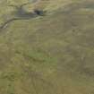
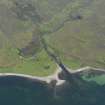
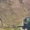
On-line Digital Images |
DP 032046 |
RCAHMS Aerial Photography Digital |
Oblique aerial view centred on the remains of the township, taken from the NW. |
4/5/2007 |
Item Level |
|
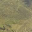 |
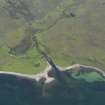
On-line Digital Images |
DP 032047 |
RCAHMS Aerial Photography Digital |
Oblique aerial view centred on the remains of the township, taken from the WNW. |
4/5/2007 |
Item Level |
|
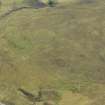 |
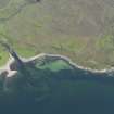
On-line Digital Images |
DP 032048 |
RCAHMS Aerial Photography Digital |
Oblique aerial view centred on the remains of the township, taken from the W. |
4/5/2007 |
Item Level |
|
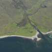 |
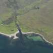
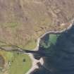
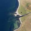
On-line Digital Images |
DP 076884 |
RCAHMS Aerial Photography Digital |
General oblique aerial view of the township and fish trap at the mouth of the Abhainn Inbhir Ghiuserein and Inverguseran, taken from the NW. |
1/6/2009 |
Item Level |
|
 |
On-line Digital Images |
DP 076885 |
RCAHMS Aerial Photography Digital |
General oblique aerial view of the township and fish trap at the mouth of the Abhainn Inbhir Ghiuserein and Inverguseran, taken from the WNW. |
1/6/2009 |
Item Level |
|
 |
On-line Digital Images |
DP 076886 |
RCAHMS Aerial Photography Digital |
General oblique aerial view of the township and fish trap at the mouth of the Abhainn Inbhir Ghiuserein and Inverguseran, taken from the WNW. |
1/6/2009 |
Item Level |
|
 |
On-line Digital Images |
DP 076887 |
RCAHMS Aerial Photography Digital |
General oblique aerial view of the township and fish trap at the mouth of the Abhainn Inbhir Ghiuserein and Inverguseran, taken from the W. |
1/6/2009 |
Item Level |
|
 |
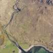
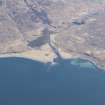
On-line Digital Images |
DP 076899 |
RCAHMS Aerial Photography Digital |
Oblique aerial view looking along the River Morar across the bridges, taken from the W. |
1/6/2009 |
Item Level |
|
 |
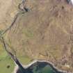
On-line Digital Images |
DP 111863 |
RCAHMS Aerial Photography Digital |
Oblique aerial view of the remains of a fish trap, township, field system and head dyke at Niag Ard, near Inverguseran on the Knoydart Peninsula, taken from the N. |
1/5/2011 |
Item Level |
|
 |
On-line Digital Images |
DP 111864 |
RCAHMS Aerial Photography Digital |
Oblique aerial view of the remains of a fish trap, township, field system and head dyke at Niag Ard, near Inverguseran on the Knoydart Peninsula, taken from the N. |
1/5/2011 |
Item Level |
|
 |
On-line Digital Images |
DP 111865 |
RCAHMS Aerial Photography Digital |
Oblique aerial view of the remains of the township, field system and head dyke at Niag Ard, near Inverguseran on the Knoydart Peninsula with the fish trap adjacent, taken from the NW. |
1/5/2011 |
Item Level |
|
 |
On-line Digital Images |
DP 111866 |
RCAHMS Aerial Photography Digital |
Oblique aerial view of the remains of the township, field system and head dyke at Niag Ard, near Inverguseran on the Knoydart Peninsula with the fish trap adjacent, taken from the NW. |
1/5/2011 |
Item Level |
|
 |
On-line Digital Images |
DP 111867 |
RCAHMS Aerial Photography Digital |
Oblique aerial view of the remains of a fishtrap, township, field system and head dyke at Niag Ard, near Inverguseran on the Knoydart Peninsula, taken from the SSW. |
1/5/2011 |
Item Level |
|
 |
On-line Digital Images |
DP 162762 |
RCAHMS Aerial Photography Digital |
General oblique aerial view of Inverguseran, looking E. |
2/4/2013 |
Item Level |
|
 |
On-line Digital Images |
SC 2360184 |
Records of the Ordnance Survey, Southampton, Hampshire, England |
Niag-Ard, NG70NW 3, Ordnance Survey index card, page number 1, Recto |
1958 |
Item Level |
|
 |
On-line Digital Images |
SC 2360185 |
Records of the Ordnance Survey, Southampton, Hampshire, England |
Niag-Ard, NG70NW 3, Ordnance Survey index card, Recto |
1958 |
Item Level |
|


