
Pricing Change
New pricing for orders of material from this site will come into place shortly. Charges for supply of digital images, digitisation on demand, prints and licensing will be altered.
Ballourie


Rig And Furrow (Medieval) - (Post Medieval), Township (Period Unassigned)
Site Name Ballourie
Classification Rig And Furrow (Medieval) - (Post Medieval), Township (Period Unassigned)
Alternative Name(s) Pitourie
Canmore ID 115896
Site Number NH80NW 13
NGR NH 8330 0705
NGR Description Centred on NH 8399 0797
Datum OSGB36 - NGR
Permalink http://canmore.org.uk/site/115896


- Council Highland
- Parish Alvie
- Former Region Highland
- Former District Badenoch And Strathspey
- Former County Inverness-shire
NH80NW 13.00 centred 8330 0705
NH80NW 13.01 NH 8317 0698 Farmstead
NH80NW 13.02 NH 8338 0705 Farmstead
NH80NW 13.03 NH 8347 0709 Farmstead
NH80NW 13.04 NH 8316 0708 Farmstead
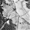
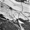
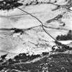
A township of three foci comprising a total of ten roofed buildings, two unroofed buildings and seven enclosures are depicted on the 1st edition of the OS 6-inch map (Inverness-shire 1874, sheet lxxiii). Two roofed, three unroofed buildings and two enclosures are shown on the current edition of the OS 1:10000 map (1995).
Information from RCAHMS (AKK) 12 July 1996.
The following site was discovered during fieldwalking in the Strathspey Rabbit Control Pilot Scheme Survey:
NH 8312 0696 Unenclosed settlement.
Sponsor: Cairngorms Partnership.
D Rankin 1998
Aerial photography (RCAHMSAP 1995) has recorded traces of rig and furrow cultivation running for at least 200m to the SE of the previously described township.
Information from RCAHMS (KB) 5 May 1999

