 |
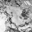
On-line Digital Images |
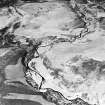
SC 1695813 |
RCAHMS Aerial Photography |
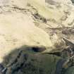
Oblique aerial view of Achad a'Chatha, taken from the W, centred on the remains of a township. Another township is visible on the opposite bank of Raitts Burn. |
13/5/1996 |
Item Level |
|
 |
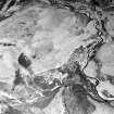
On-line Digital Images |
SC 1695814 |
RCAHMS Aerial Photography |
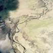
Oblique aerial view of Achad a'Chatha, taken from the WSW, centred on the remains of a township. Another township is visible in the bottom left of the photograph and a farmstead is visible in the upper centre. |
13/5/1996 |
Item Level |
|
 |
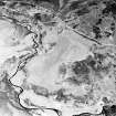
On-line Digital Images |
SC 1695816 |
RCAHMS Aerial Photography |
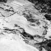
Oblique aerial view of Achad a'Chatha, taken from the N, centred on the remains of a township. |
13/5/1996 |
Item Level |
|
 |
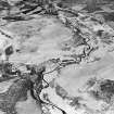
On-line Digital Images |
SC 1695817 |
RCAHMS Aerial Photography |
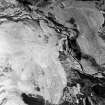
Oblique aerial view of Achad a'Chatha, taken from the SE, centred on the remains of a township. Another township is visible on the opposite bank of Raitts Burn. |
13/5/1996 |
Item Level |
|
 |
On-line Digital Images |
SC 1695818 |
RCAHMS Aerial Photography |
Oblique aerial view of Achad a'Chatha, taken from the SE, centred on the remains of a township. |
13/5/1996 |
Item Level |
|
 |
On-line Digital Images |
SC 1695822 |
|
Achadh a' Chatha, oblique aerial view, taken from the W, centred on the remains of a township. A farmstead is visible in the top left-hand corner of the photograph. |
13/5/1996 |
Item Level |
|
 |
On-line Digital Images |
SC 1695823 |
RCAHMS Aerial Photography |
Achadh a' Chatha, oblique aerial view, taken from the SW, centred on the remains of a township. Part of a second township is visible in the centre right half of the photograph. |
13/5/1996 |
Item Level |
|
 |
On-line Digital Images |
SC 1695824 |
RCAHMS Aerial Photography |
Achadh a' Chatha, oblique aerial view, taken from the SW, centred on the remains of two townships. A farmstead is visible in the top centre half of the photograph. |
13/5/1996 |
Item Level |
|
 |
On-line Digital Images |
SC 1695825 |
RCAHMS Aerial Photography |
Achadh a' Chatha, oblique aerial view, taken from the S, centred on the remains of a township. Part of a second township is visible in the centre right half of the photograph. |
13/5/1996 |
Item Level |
|
 |
On-line Digital Images |
SC 1695826 |
RCAHMS Aerial Photography |
Achadh a' Chatha, oblique aerial view, taken from the SSW, centred on the remains of a township. A farmstead is visible in the top right-hand corner of the photograph. |
13/5/1996 |
Item Level |
|
 |
On-line Digital Images |
SC 1695827 |
RCAHMS Aerial Photography |
Achadh a' Chatha, oblique aerial view, taken from the SE, centred on the remains of two townships. |
13/5/1996 |
Item Level |
|
 |
On-line Digital Images |
SC 1695828 |
RCAHMS Aerial Photography |
Achadh a' Chatha, oblique aerial view, taken from the SE, centred on the remains of two townships. |
13/5/1996 |
Item Level |
|


