
Pricing Change
New pricing for orders of material from this site will come into place shortly. Charges for supply of digital images, digitisation on demand, prints and licensing will be altered.
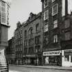
Edinburgh, 24, 26 And 28 High Street, Fountain Close


Shop(S) (Period Unknown), Tenement (Period Unknown)
Site Name Edinburgh, 24, 26 And 28 High Street, Fountain Close
Classification Shop(S) (Period Unknown), Tenement (Period Unknown)
Canmore ID 115458
Site Number NT27SE 1161
NGR NT 26095 73675
Datum OSGB36 - NGR
Permalink http://canmore.org.uk/site/115458


- Council Edinburgh, City Of
- Parish Edinburgh (Edinburgh, City Of)
- Former Region Lothian
- Former District City Of Edinburgh
- Former County Midlothian
Depicted on the coloured 1st edition of the O.S. 1:1056 scale map (Edinburgh and its Environs, 1854, sheet 36).
Fountain Close is named on Edgar 1742 and formed a group not only with the great tenement at the close head, called "the Fountain" in 1727, but with the "Fountain well", recorded thus in 1736, and part of the water supply system completed in 1681. While the close could have been named for the house or vice versa, it is difficult to see why either should have been named for the well, for there are several other closes and many other buildings closer to it in its present position, which is substantially the same as that shown on Edgar 1742 and Ainslie 1804 -a change of its position, instructed in 1813 (if it was carried out) must have been quite small. It is more reasonable to suppose that the present well got its name from being in the general vicinity of the mansion, and that the mansion and the close must have been named for another well, now lost, in the close or at its head. It is suggested in Wilson, but scarcely proved, that it was the "Endmyleis well" (a name fleetingly resembling that of World's End Close) which is mentioned in the evidence of the trial of Darnley's murderers in 1567. The close was also John Barton's Close, evidently for the owner of a cachepell or royal-tennis court at its foot, whose widow is listed as an owner occupier in 1635. It was also Stevenson's or David Stevenson's Close for some owner(s), at some date as yet unascertained, of the Fountain tenement. This was earlier owned by the Bassenden family, including James Bassenden, who was active in the Netherbow area from 1537 onwards, and also the famous Scottish printer Thomas Bassenden, who died in 1577. As well as being Bassenden's Close (later South Bassenden's Close, simply to distinguish it from the close on the north side of the street) the close was Fullarton's Close, for Adam Fullartoun, merchant, prominent in the town, from 1552-82, as councillor, bailie and finally dean of guild, who built or rebuilt his house on the east side of the close in 1573 after it had been used as a gun platform in the defence of Edinburgh by the Queen's Men under Kirkcaldy of Grange. But the earliest name of the close is given in RMS (Register of the Great Seal of Scotland, Vols I-XI) 1478 as "le Soltrais Wynde", still in use in 1635 as Soltray's Close, and evidently derived from a connection with the hospice of Soltre or Soutra, founded by Malcolm IV in or before 1164 for shelter of travellers. Land in the Cowgate feued from the Master of the hospice is mentioned in RMS 1481, together with an adjoining owner, Thomas de Sowtre, who may have been the Master himself. (from Stuart Harris, "Place Names of Edinburgh", 1996, pages 278-9)
REFERENCE: NMRS HISTORICAL FILE
2 pages of text relating the acquisition of house and grounds in Fountain Close by College of Physicians in 1704-1770 -filed under "PHYSICIANS' HALL, FOOT OF FOUNTAIN CLOSE, 1722"
NMRS REFERENCE:
Printroom.
Edinburgh Architectural Association Sketchbook 1875-76 - reproduction of a pencil drawing.
Unable to locate at time of upgrade 15.2.2000.

