
Arbroath, Keptie Hill, Water Tower


Water Tower (19th Century)
Site Name Arbroath, Keptie Hill, Water Tower
Classification Water Tower (19th Century)
Alternative Name(s) Keptie Hills; Hillend Road; Addison Place
Canmore ID 114865
Site Number NO64SW 130
NGR NO 63534 40785
Datum OSGB36 - NGR
Permalink http://canmore.org.uk/site/114865


- Council Angus
- Parish Arbroath And St Vigeans
- Former Region Tayside
- Former District Angus
- Former County Angus
NO64SW 130 63534 40785
Water Tower
(Arbroath Corporation Water Works) [NAT]
OS (GIS) ep. 2.
Water Tower (dis) [NAT]
OS 1:10,000 map, 1986.
Water Tower (disused) [NAT]
OS (GIS) AIB, April 2006.
NMRS REFERENCE:
Architect: William G Lamond 1885.
(Undated) information in NMRS.
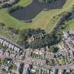
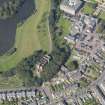
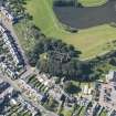
(Location cited as NO 637 408). Water-tower, Keptie Hill, built 1885, architect William Gillespie Lamond. A remarkable structure, basically rectangular, with battered coursed-rubble walls, topped by machiolated battlements. At the S end is a square tower with a circular corner turret.
J R Hume 1977.
This water tower occupies an elevated location within an area of residential development on the W side of Arbroath (NO64SW 46).
Information from RCAHMS (RJCM), 19 April 2006.
This water tower has three tanks: the larger, central tank is bolted on the inside. The roof has been taken down.
Information from RCAHMS (MMD), 27 August 2009
Sham medieval tower in rusticated red sandstone with machicolated battlements. A square tower with a circular corner turret sits at the south end. The interior retains its original water tanks. (Historic Scotland)
The Water Tower was built with the labour of unemployed in Arbroath in an early form of workfare. It was designed by Friockheim architect William Gillespie Lamond in the style of a fake medieval fortress with rusticated red sandstone walls and became locally known as Arbroath's castle. It was designed to provide the town with an adequate drinking water supply but was only operational for 20 years. The Tower contained three lined tanks with a total capacity of 200,000 gallons. The location was chosen because of a natural spring that flowed there but the use of the Tower was discontinued following the provision of a greater water supply from Glenogil. In 1937 the land surrounding the Water Tower was given to the Town Council for use as a park, a function it retains to this day. (Angus Council).
Design (1882)
Designed, but not executed by architect and civil engineer, W Gillespie Lamond, from Friokheim.
Publication Account (2007)
With its battered coursed red-rubble sandstonewalls topped by machicolated battlements this water tower is a dramatic feature of the Arbroath skyline and an impressive example of high Victorian achievement in a local context. Its details from a plaque on the tower read:
‘THE WATER TOWER. The drought of 1870 and the increase in housing around Arbroath precipitated the Arbroath Corporation to seek a supplementary water supply. By 1882 the Water Committee of the Police Board had resolved to sink the
wells between Holt Loans and Keptie Hill on ground leased from Mr. Colvill’s patrons and to erect distribution tanks on the hill with a pumping station at the wells.
The Police Board sought permission from Mr. Colvill’s patrons to erect a tank on Keptie Hill. However, the Patrons disapproved of the building sketched for them by the Superintendent of Police and were of the opinion that ‘‘having regard to the prominent situation the building will occupy, it is essential that the proposed erection shall be of an ornate character’’.
Friockheim architect, W. Gillespie Lamont designed the water tower for a fee of £55 and Archibald Anderson was the builder of the project which cost roughly £8,000. In July 1885 the water was turned on from Keptie Hill. When full the
three tanks held almost 200,000 gallons, each tank weighing 284 tons. However, the water tower proved insufficient for the increasing demand for water and a plan to take a supply from the Noran Water at Glenogil was completed in 1908,
thus making the water tower surplus to requirements.’
Lamond (1854–1912), his name is incorrectly spelt above, also practised as a civil engineer. After a dispute, the building of the tower was supervised by the Corporation’s Surveyor, hence the smallness of Lamond’s fee.
R Paxton and J Shipway 2007b
Reproduced from 'Civil Engineering heritage: Scotland - Highlands and Islands' with kind permission of Thomas Telford Publishers.
Publication Account (2013)
Three cast iron water cisterns are in a stone edifice designed by WG Lamond to look like a Spanish castle, 1885, as the trustees of the land demanded something more edifying than the first proposal. It stands in a public park. The water tower held 200,000 gallons pumped from wells. In 1908 it was superseded by a water supply from Glen Ogil but was declared on BBC Radio 4 to be the best-looking in Britain.
M Watson, 2013

