
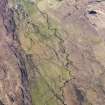
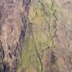
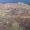
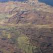
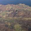
Skye, Allt An Loin Ruaidh


Farmstead (Period Unassigned), Field System (Period Unassigned)
Site Name Skye, Allt An Loin Ruaidh
Classification Farmstead (Period Unassigned), Field System (Period Unassigned)
Canmore ID 114725
Site Number NG35SE 20.01
NGR NG 3802 5210
Datum OSGB36 - NGR
Permalink http://canmore.org.uk/site/114725


- Council Highland
- Parish Snizort
- Former Region Highland
- Former District Skye And Lochalsh
- Former County Inverness-shire
Note
A farmstead, comprising one roofed, one unroofed building and an enclosure, and a field-system is depicted on the 1st edition of the OS 6-inch (Inverness-shire, Isle of Skye 1881, sheet xvi). Two unroofed buildings, one enclosure and a field-system are shown on the current edition of the OS 1:10560 map (1969).
Information from RCAHMS (AKK) 17 October 1996.

