
Following the launch of trove.scot in February 2025 we are now planning the retiral of some of our webservices. Canmore will be switched off on 24th June 2025. Information about the closure can be found on the HES website: Retiral of HES web services | Historic Environment Scotland
Unst, Saxa Vord, Royal Naval Chain Home Low Radar Station,


Radar Station (Second World War)
Site Name Unst, Saxa Vord, Royal Naval Chain Home Low Radar Station,
Classification Radar Station (Second World War)
Alternative Name(s) Cdu, Type 273 Radar Station; Admiralty Experimental Station No.4
Canmore ID 114601
Site Number HP61NW 6
NGR HP 63162 16664
NGR Description Centred HP 63162 16664
Datum OSGB36 - NGR
Permalink http://canmore.org.uk/site/114601


- Council Shetland Islands
- Parish Unst
- Former Region Shetland Islands Area
- Former District Shetland
- Former County Shetland
HP61NW 6.00 63162 16664
HP61NW 6.01 HP 6345 1543 Radio Masts; Buuildings (RN Station WW II)
HP61NW 6.02 HP 6480 1544 Building
HP61NW 6.03 HP 6468 1542 Building
HP61NW 6.04 centred HP 62980 16590 Radar Station (RAF Saxa Vord) postwar
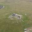
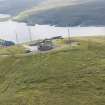
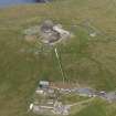
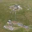
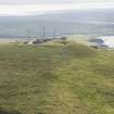
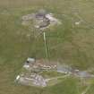
Situated within the bounds of RAF Saxa Vord, W of the Burra Firth, N Unst, is a Chain Home Low radar station. Constructed of brick and concrete it formed part of the British Isles Radar Cover.
J Guy 1995; NMRS MS 810/4, 1-2, 3-8, 13
Additional information from Mr I Brown who states that this was a coast defence U-boat (C.D.U) station which was Naval operated. A type 273 radar was mounted, a naval designation for a surface watching set, with paraboloids mounted inside a perspex 'lighthouse' type structure.
Information from Mr I Brown via e-mail to RCAHMS 19 October 1998.
The radar station is visible on vertical air photographs (106G/Scot/UK 97, 4095-4096, flown 18 May 1946), which shows that the buildings and structures associated with the installation were enclosed within a barbed-wire fence. Two barbed-wire fence enclosures are clearly visible on the photographs surrounding the radar station, an inner around the buildings and an outer enclosing an area of moorland around the station.
The buildings are in two groups, at the end of a road.
Information from RCAHMS (DE), February 2006

