
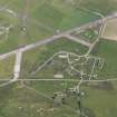
Tain Airfield, Control Tower


Air Raid Shelter (20th Century), Control Tower (20th Century)
Site Name Tain Airfield, Control Tower
Classification Air Raid Shelter (20th Century), Control Tower (20th Century)
Canmore ID 114075
Site Number NH88SW 14.05
NGR NH 83018 81699
Datum OSGB36 - NGR
Permalink http://canmore.org.uk/site/114075


- Council Highland
- Parish Tain
- Former Region Highland
- Former District Ross And Cromarty
- Former County Ross And Cromarty
NH88SW 14.05 83018 81699
Tain airfield control tower survives as a two storey brick and concrete structure on the runway side of a collection of airfield buildings to the N of Balnagall farm. There is a further small additional storey accessed by a narrow concrete staircase. Although in a semi-derelict state with the upper front floor area removed, it still retains many of the internal divisions. The ground floor rooms have been considerably reduced in internal height by the deposition of many years of cattle waste. Two painted door signs survive on the upper floor, both are above a door and small window respectively and state 'Enquiries'.
Immediately to the W is a standard brick built blast shelter.
Visited by RCAHMS (DE) January 1997.

