
Following the launch of trove.scot in February 2025 we are now planning the retiral of some of our webservices. Canmore will be switched off on 24th June 2025. Information about the closure can be found on the HES website: Retiral of HES web services | Historic Environment Scotland
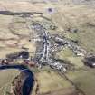
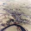
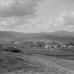
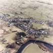
St John's Town Of Dalry, General


Town (Period Unassigned)
Site Name St John's Town Of Dalry, General
Classification Town (Period Unassigned)
Canmore ID 113890
Site Number NX68SW 97
NGR NX 6224 8125
NGR Description Centred on NX 6224 8125
Datum OSGB36 - NGR
Permalink http://canmore.org.uk/site/113890


- Council Dumfries And Galloway
- Parish Dalry (Stewartry)
- Former Region Dumfries And Galloway
- Former District Stewartry
- Former County Kirkcudbrightshire

