
Pricing Change
New pricing for orders of material from this site will come into place shortly. Charges for supply of digital images, digitisation on demand, prints and licensing will be altered.
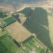
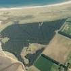
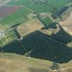
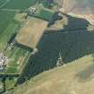
Hedderwick Hill Plantation


Machine Gun Post (First World War), Trench(S) (First World War), Trench (Second World War)(Possible)
Site Name Hedderwick Hill Plantation
Classification Machine Gun Post (First World War), Trench(S) (First World War), Trench (Second World War)(Possible)
Canmore ID 113795
Site Number NT67NW 77
NGR NT 6456 7933
NGR Description From c.NT 6438 7944 to c.NT 6488 7904
Datum OSGB36 - NGR
Permalink http://canmore.org.uk/site/113795


- Council East Lothian
- Parish Dunbar
- Former Region Lothian
- Former District East Lothian
- Former County East Lothian
A War office map of 1916 (the National Archives WO 78/4396) shows anti-invasion defences around West Barns Links (now Hedderwick Hill Plantation), at that time an expanse of grass-covered sand-dunes on which there was a firing range. There were two 'redoubts', formed of trenches surrounded by barbed wire at the east and west ends of the complex. The 'Tyneside redoubt' at NT 64036 79276 looked out over the mouth of the River Tyne, while the 'Bielside Redoubt' at NT 65117 78838 looked out onto Belhaven Sands. Between NT 62419 79431 and the Bielside Redoubt there was a discontinuous series of firing trenches line along the head of the beach, incorposrating four machine-gun emplacements. A 'communication trench' running from NT 64380 78879 to NT 64775 79098 gave access to the coastal firing positions. The defences continued a little to the east of the Bielside Redoubt, with what are described on the map as 'shelters' and a length of 'defensible wall' to the mouth of the Biel water. A further length of defensible wall about 150m long was marked to the south of the communication trench, at NT 6476 78825.
The trenches are visible on modern and Second World War aerial photographs. The available maps of the defences here in the Second World War (by 17th Battalion Durham Light Infantry and the Polish Army)(The National Archives WO 166/4231; Polish Institute and Sikorski Museum file A.VI.31/2 "Odcinek [Sector] East Lothian") shows defences in this area but do not show extensive trenching; remarks on War Office files of that period do hint at the existence of firing trenches and it is possible that some of the First World War positions were re-used.
Information from HS/RCAHMS World War One Audit Project (GJB) 10 September 2013.
NT67NW 77 from c.6438 7944 to c.6488 7904
NT 644 793. Site recorded during a rapid coastal survey undertaken by GUARD of the S shore of the Firth of Forth from Dunbar to Stirling and along the N shore of the Forth to the Fife border. A gazetteer of all sites including listed buildings, designed landscapes, scheduled and unscheduled monuments was produced. Full details of the survey can be consulted in the report held by the NMRS.
Sponsor: Historic Scotland
GUARD 1996
Remains of WW2 slit trenches still visible in sand dunes on 1988 AP's. C279 133-4 7/6/88.
Site recorded by GUARD during the Coastal Assessment Survey for Historic Scotland, 'The Firth of Forth from Dunbar to the Coast of Fife' 1996.
Field Visit (1996)
Remains of WW2 slit trenches still visible in sand dunes on 1988 AP's. C279 133-4 7/6/88.
Site recorded by GUARD during the Coastal Assessment Survey for Historic Scotland, 'The Firth of Forth from Dunbar to the Coast of Fife' 1996.
Project (March 2013 - September 2013)
A project to characterise the quantity and quality of the Scottish resource of known surviving remains of the First World War. Carried out in partnership between Historic Scotland and RCAHMS.
Note (November 2017)
Defending the coast
In times of conflict Britain has always kept a careful eye on her European neighbours for fear of attack or invasion. Never more so than during the Second World War. Following the defeat in Norway and the humiliation of both the French and British armies in Northern France, Britain faced the very real prospect of invasion. Defensive measures were quickly drawn up by General Edmund Ironside, the officer charged with defending Britain, who advocated that fixed defences, or ‘Stop Lines’, should be established across the UK; and in particular, the construction of beach defences. Described as a ‘coastal crust’, the defences were designed to delay, restrict and reduce the invading forces until a coordinated response could be mobilised by the British army.
In preparation, the whole coast of the UK was assessed in terms of its potential for invasion and where weaknesses were perceived these beaches were strengthened by the rapid construction of defences. The most self-evident today are the anti-tank blocks: lines of large concrete cubes designed to stop vehicles and tanks from leaving the beach. However, these were augmented by tangles of barbed wire laid between and around them, while other deterrents such as minefields, pillboxes and anti-tank ditches increased their resistance. All were designed to slow the enemy down and restrict their movements to the beach where they would become easy prey for the defending troops and air force.
The East Lothian coastline between Port Seton and Dunbar was appraised as particularly at threat from a seaborne landing due to its gently sloping beaches and relatively sheltered water. In June 1940, Scottish Command identified two especial areas of concern: Tentsmuir in Fife and the beaches to the west of Dunbar – namely those at Hedderwick, and Tyninghame. A document of October 1940, entitled ‘Scottish Command Defence Scheme’, provides a detailed insight into the plans for these vulnerable areas, together with maps of the fixed defences. These were supplemented by additional works, which were constructed up to at least 1942. Soldiers from across the UK, including hundreds of Polish servicemen, worked for months building the coastal ‘crust’ in East Lothian and all along the Scottish seaboard.
What now survives
A walk along the shore at Hedderwick and Tyninghame is a walk through the remains of these defences. Some are clearly visible, others require more careful inspection, but a surprising proportion survives. An almost unbroken line of anti-tank blocks once extended from Belhaven Bay to St Baldred’s Cradle, a distance of 8km. The Tyninghame shoreline still has a 2.5km long section, including two road-blocks of which the more northerly is particularly well preserved. It comprises two large concrete blocks with slots or holes for the insertion of metal rails and four concrete cylinders that were positioned below them. On the headland of St Baldred’s Cradle, itself, are the remains of a number of trenches and partly collapsed pill-boxes, which overlook Ravensheugh Sands. One of the pill-boxes has an inscription cut in the wet cement, which reads ‘D.C Middlesex 13 Platoon’ - a unit whose presence here is confirmed by other military records. In addition, there are the remains of an observation post perched on top of a prehistoric cairn. This was once intended to direct fire towards the beaches from two large six-inch naval guns located at Bowerhouse, some 5.5km distant. And to the south of St Baldred’s Cradle can be found the only intact pill-box and what appears to be an earlier trench.
The beaches at Ravensheugh and Belhaven Bay, as well as the tidal basin that lies between Tyninghame and Hedderwick, offered a large flat area of ground suitable for enemy glider or troop aircraft operations. To counter this, a system of ‘Anti-Glider Poles’ were erected. Long lines of vertical timber posts set within a concrete pipe were laid-out in a grid like fashion to prevent any form of aircraft landing on the beach. There are also once at least five pill-boxes within the tidal basin and along the shore to the south, but these have now been largely been removed
A forestry plantation grows where golf was once played on the links of Hedderwick, but during the war this area was a large minefield and aerial photographs from 1945 show placements of barbed wire demarking this dangerous area. These images also record a system of trenches in the dunes on the seaward side of the plantation. They, together perhaps with those that can be seen beside the surviving pill-box at Tyninghame, are a rare survival of the First World War beach defences. About 700m of the original system can still be traced here, although much survives only as a long shallow zig-zag depression. However, at its north end, the actual trench survives well and measures over 1.5m wide and 1.3m deep. This length of the front line is longer than any surviving in Belgium and illustrates the considerable efforts that were made to fortify the coastline in 1914-18. This defence was not reused in 1940, as it was no longer considered suitable.
Most of the remains south of Hedderwick have been lost, although some concrete blocks can still be observed at Winterfield Golf Course, where they have been piled up to combat coastal erosion.
The unique mix of both First and Second World War defences along this small stretch of the Scottish coast demonstrates the efforts that were made to protect the country from seaborne invasion. Despite efforts to remove entire sections in order to restore the countryside, much still survives recalling those dark and menacing times and the defences that remain are now recognised as an indivisible part of our heritage.
Allan Kilpatrick, Data Management Officer, Historic Environment Scotland

