
Pricing Change
New pricing for orders of material from this site will come into place shortly. Charges for supply of digital images, digitisation on demand, prints and licensing will be altered.
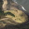
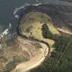
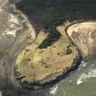
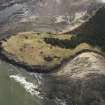
Whitberry Point


Pillbox(S) (Second World War) (1940), Trench(S) (20th Century)
Site Name Whitberry Point
Classification Pillbox(S) (Second World War) (1940), Trench(S) (20th Century)
Alternative Name(s) Links Wood; St Baldred's Cradle
Canmore ID 113705
Site Number NT68SW 45
NGR NT 6355 8125
NGR Description NT 6354 8124, NT 6355 8125 and NT 6358 8126
Datum OSGB36 - NGR
Permalink http://canmore.org.uk/site/113705


- Council East Lothian
- Parish Whitekirk And Tyninghame
- Former Region Lothian
- Former District East Lothian
- Former County East Lothian
NT68SW 45 6354 8124, 6325 8125 and 6358 8126
Site recorded during a rapid coastal survey undertaken by GUARD of the S shore of the Firth of Forth from Dunbar to Stirling and along the N shore of the Forth to the Fife border. A gazetteer of all sites including listed buildings, designed landscapes, scheduled and unscheduled monuments was produced. Full details of the survey can be consulted in the report held by the NMRS.
NT 635 812 WW2 pillbox
NT 635 812 WW2 trench
NT 636 813 WW2 trench
Sponsor: Historic Scotland
GUARD 1996
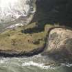
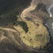
A concrete pill-box and slabs of concrete are visible from Bathan's Strand half way down the cliff face at the east end of the bay. The site was not visited because of its position. The pill-box had a slot on one side. It was unclear if the slabs of concrete had been dumped or were from a collapsed structure. The entire west facing cliff face was slumping.
A V-shaped trench on the west edge of a promontory commanding excellent views of Bathan's Strand. The trench is between 1.80m and 1m deep and 15m long, at the south end the trench is on either side of an up-cast mound of sand and stone. There is some signs of slumping and animal damage. This trench visible on 1946 AP's. B108 7196-7 15/4/46.
Site recorded by GUARD during the Coastal Assessment Survey for Historic Scotland, 'The Firth of Forth from Dunbar to the Coast of Fife' 17th February 1996.
At NT 6354 8124 are the remains of a possible pillbox. The collapsed concrete sections now lie on the foreshore, all showing evidence of the use of corrugated iron for shuttering during construction. Whether this was a pillbox was difficult to ascertain due to the condition of the remains on the date of visit. By the size and shape it is probable that it was a pillbox.
About 30m to the NE (NT 6355 8125) is another concrete platform with the broken sections of reinforced concrete lying on the foreshore. The shape and size of this structure would suggest that it was an observation post rather than a pillbox.
About 40-50m inland from the two concrete structures described above is a small trench system almost certainly of Second World War date. That which is nearest to the shoreline is of a z-shaped construction with a loop at the southern end. A further 30m E is another L-shaped trench, possibly a small redoubt constructed to protect the rear of the forward trench at NT 6358 8126. This may have been mistaken for a pillbox in 1975 (see NT 68SW 4.01) as there is a concrete structure buried under the thick marram grass and brambles.
Information from RCAHMS and visited by D Easton, December 2001
Field Visit (17 February 1996)
A concrete pill-box and slabs of concrete are visible from Bathan's Strand half way down the cliff face at the east end of the bay. The site was not visited because of its position. The pill-box had a slot on one side. It was unclear if the slabs of concrete had been dumped or were from a collapsed structure. The entire west facing cliff face was slumping.
A V-shaped trench on the west edge of a promontory commanding excellent views of Bathan's Strand. The trench is between 1.80m and 1m deep and 15m long, at the south end the trench is on either side of an up-cast mound of sand and stone. There is some signs of slumping and animal damage. This trench visible on 1946 AP's. B108 7196-7 15/4/46.
Site recorded by GUARD during the Coastal Assessment Survey for Historic Scotland, 'The Firth of Forth from Dunbar to the Coast of Fife' 17th February 1996.

