
Tantallon, Gin Head, Admiralty Signals Establishment Extension


Military Installation (20th Century), Scientific Research Establishment (20th Century)
Site Name Tantallon, Gin Head, Admiralty Signals Establishment Extension
Classification Military Installation (20th Century), Scientific Research Establishment (20th Century)
Alternative Name(s) Castletown
Canmore ID 113691
Site Number NT58NE 59
NGR NT 59306 85257
NGR Description Centred NT 59306 85257
Datum OSGB36 - NGR
Permalink http://canmore.org.uk/site/113691


- Council East Lothian
- Parish North Berwick
- Former Region Lothian
- Former District East Lothian
- Former County East Lothian
NT58NE 59 centred 59306 85257
See also NT58NE 58.
Site recorded during a rapid coastal survey undertaken by GUARD of the S shore of the Firth of Forth from Dunbar to Stirling and along the N shore of the Forth to the Fife border. A gazetteer of all sites including listed buildings, designed landscapes, scheduled and unscheduled monuments was produced. Full details of the survey can be consulted in the report held by the NMRS.
NT 592 852 Research laboratory.
Sponsor: Historic Scotland
GUARD 1996
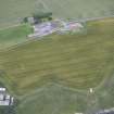
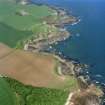
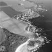
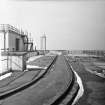
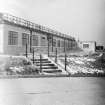
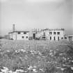
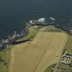
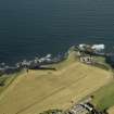
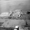
Flat roofed buildings and concrete roadways, seen on 1946 aerial photographs. Appearance of buildings suggest they are of recent or wartime construction. Site still in use on 1974 and 1988 aerial photographs, but some structures have been demolished and replaced. B108 7287-8 15/4/46.
Site recorded by GUARD during the Coastal Assessment Survey for Historic Scotland, 'The Firth of Forth from Dunbar to the Coast of Fife' 1996.
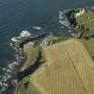
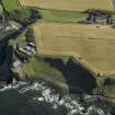
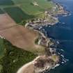
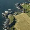
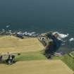
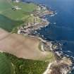
This research establishment was opened in 1943 to develop radar for the Royal Navy. The base was also used to test the effectiveness of radio countermeasures equipment prior to the D-day landings in June 1944.
The site was sold to Ferranti's Ltd in 1948 and now lies derelict.
Information from RCAHMS (DE) and Mr I Brown, July 2004.
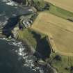
The group comprising the former Royal Navy Research Establishment are visible on oblique aerial photographs taken in September 2007 (RCAHMS 2007), which show large flat roofed buildings at a lower level (NT 59316 85310) with a further group centred at NT 59293 85262 at the upper level.
One structure is noted on Taking Head at NT 59058 85310.
Information from RCAHMS (DE), December 2007.
Field Visit (1996)
Flat roofed buildings and concrete roadways, seen on 1946 aerial photographs. Appearance of buildings suggest they are of recent or wartime construction. Site still in use on 1974 and 1988 aerial photographs, but some structures have been demolished and replaced. B108 7287-8 15/4/46.
Site recorded by GUARD during the Coastal Assessment Survey for Historic Scotland, 'The Firth of Forth from Dunbar to the Coast of Fife' 1996.
Standing Building Recording (October 2005)
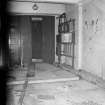
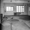
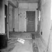
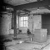
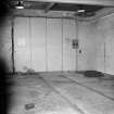
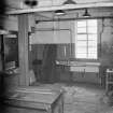
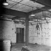
NT 593 852 A desk-based assessment and historic building survey of the research station and former signals establishment at Gin Head, near North Berwick, were undertaken in October 2005 in advance of proposals to develop the site for housing. The site closed in 1993-4, since when it has lain derelict. The original site and many of the surviving buildings were constructed in 1943 specifically to test naval radars, including examples of captured German radar equipment. It continued to be used by the Admiralty after the war for radar trials and was later sold to Ferranti.
Despite lacking any statutory protection, the site is identified as a historically important group of buildings. The physical remains of the buildings have been fully recorded.
Report lodged with East Lothian SMR and NMRS.
Sponsor: Dunglass Ltd.
A Dutton, C Lowe 2005.

