|
Print Room |
G 90743 PO |
Records of Messrs Inglis, landscape and architectural photographers, Edinburgh, Scotland |
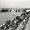
View from fountain end. |
|
Item Level |
|
|
Manuscripts |
MS 725/138 |
Historic Scotland Archive Project |
Report of coastal assessment survey for Historic Scotland: The Firth of Forth from Dunbar to the border of Fife. (3 volumes)
Revised version with amended text. |
1996 |
Item Level |
|
|
Manuscripts |
MS 2221/05 |
Historic Scotland Archive Project |
Survey archive: List of Vertical Aerial Photographs consulted in the NMRS, from Coastal Assessment Survey, 'The Firth of Forth from Dunbar to the Coast of Fife'. |
1996 |
Item Level |
|
 |
On-line Digital Images |
SC 1268715 |
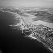
Records of Aerofilms Ltd, aerial photographers, Bristol, England |
Cockenzie and Port Seton, general view, showing Port Seton Harbour and Longniddry. Oblique aerial photograph taken facing east. |
10/9/1947 |
Item Level |
|
 |
On-line Digital Images |
DP 448725 |
Records of the Scottish Cultural Resources Access Network (SCRAN), Edinburgh, Scotland |
The Swimming Pool, Port Seton |
1/8/1935 |
Item Level |
|
|
Manuscripts |
MS 2221/01 |
Historic Scotland Archive Project |
Survey archive: Photographic register from Coastal Assessment Survey, 'The Firth of Forth from Dunbar to the Coast of Fife'. |
1996 |
Batch Level |
|
|
Photographs and Off-line Digital Images |
BP 55/04 CN |
Historic Scotland Archive Project |
Survey photographs: World War 2 anti-tank blocks and other defences from Gosford to Port Seton with sea walls at Gosford, Longniddry and Port Seton; views of Kilspindie Castle and Cockenzie House harbour and saltpans; Port Seton harbour and new Co-op store. |
1996 |
Batch Level |
|
|
Photographs and Off-line Digital Images |
BS 47/04 CS |
Historic Scotland Archive Project |
Survey photographs: Gosford, Ferny Ness and Longniddry WW2 defences with post medieval culvert at Gosford; Kilspindie Castle; Port Seton sea wall, harbour,swimming pool and street buildings; Prestonpans sea and boundary walls; Cockenzie House, harbour and salt pans. |
1996 |
Batch Level |
|
|
Manuscripts |
MS 2221/02 |
Historic Scotland Archive Project |
Survey archive: Record sheets from Coastal Assessment Survey, 'The Firth of Forth from Dunbar to the Coast of Fife'. |
1996 |
Batch Level |
|
|
Manuscripts |
MS 2221/03 |
Historic Scotland Archive Project |
Survey archive: Record sheets and maps of Erosion Units, from Coastal Assessment Survey, 'The Firth of Forth from Dunbar to the Coast of Fife'. |
1996 |
Batch Level |
|
|
Manuscripts |
MS 2221/04 |
Historic Scotland Archive Project |
Survey archive: Record sheets and maps of Geology and Coastal Geomorphology Units , from Coastal Assessment Survey, 'The Firth of Forth from Dunbar to the Coast of Fife'. |
1996 |
Batch Level |
|


