
Pricing Change
New pricing for orders of material from this site will come into place shortly. Charges for supply of digital images, digitisation on demand, prints and licensing will be altered.
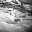
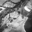
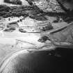
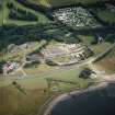
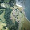
Prestongrange


Structure (Period Unassigned)
Site Name Prestongrange
Classification Structure (Period Unassigned)
Alternative Name(s) Morrison's Haven
Canmore ID 113114
Site Number NT37SE 106
NGR NT 37098 73824
Datum OSGB36 - NGR
Permalink http://canmore.org.uk/site/113114


- Council East Lothian
- Parish Prestonpans
- Former Region Lothian
- Former District East Lothian
- Former County East Lothian
NT37SE 106 37098 73824
Site recorded during a rapid coastal survey undertaken by GUARD of the S shore of the Firth of Forth from Dunbar to Stirling and along the N shore of the Forth to the Fife border. A gazetteer of all sites including listed buildings, designed landscapes, scheduled and unscheduled monuments was produced. Full details of the survey can be consulted in the report held by the NMRS.
Sponsor: Historic Scotland
GUARD 1996
A circular domed building constructed from concrete approximately 200m north-east of the mining museum on the north side of the new road. Standing 3m above ground and at least the same below, the concrete walls are 0.70m thick and the building is 5m in diameter. The doorway is to the south west and is fitted with an iron gate, internal fittings include an iron pulley system hanging from the roof and a metal floor. There are external iron fittings on the roof. The building may be associated with the mine workings and is no longer in use, plants are growing out of the roof, modern rubbish is on the floor, and there appears to be a resident population of pigeons.
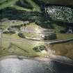
Site recorded by GUARD during the Coastal Assessment Survey for Historic Scotland, 'The Firth of Forth from Dunbar to the Coast of Fife' 1996.
A solid circular concrete structure 6m in diameter and 1m high sits on the beach at the site of Morrisons Haven 15m west of the harbour wall (NT37SE 12). It may have a WW2 defence use. The sea is eroding the bottom third of this feature.
Site recorded by GUARD during the Coastal Assessment Survey for Historic Scotland, 'The Firth of Forth from Dunbar to the Coast of Fife' 22nd February 1996.
Circular stone and concrete structure, no connection with anti-invasion defences from World War II. Central hole may have been for a small crane or post.
Visited by RCAHMS (DE), March 2005
Field Visit (22 February 1996)
A circular domed building constructed from concrete approximately 200m north-east of the mining museum on the north side of the new road. Standing 3m above ground and at least the same below, the concrete walls are 0.70m thick and the building is 5m in diameter. The doorway is to the south west and is fitted with an iron gate, internal fittings include an iron pulley system hanging from the roof and a metal floor. There are external iron fittings on the roof. The building may be associated with the mine workings and is no longer in use, plants are growing out of the roof, modern rubbish is on the floor, and there appears to be a resident population of pigeons.
Site recorded by GUARD during the Coastal Assessment Survey for Historic Scotland, 'The Firth of Forth from Dunbar to the Coast of Fife' 1996.
A solid circular concrete structure 6m in diameter and 1m high sits on the beach at the site of Morrisons Haven 15m west of the harbour wall (NT 37 SE 12). It may have a WW2 defence use. The sea is eroding the bottom third of this feature.
Site recorded by GUARD during the Coastal Assessment Survey for Historic Scotland, 'The Firth of Forth from Dunbar to the Coast of Fife' 22nd February 1996.

