
Following the launch of trove.scot in February 2025 we are now planning the retiral of some of our webservices. Canmore will be switched off on 24th June 2025. Information about the closure can be found on the HES website: Retiral of HES web services | Historic Environment Scotland
Swanbister House


Military Airfield (21st Century), Seaplane Base (First World War)
Site Name Swanbister House
Classification Military Airfield (21st Century), Seaplane Base (First World War)
Alternative Name(s) Scapa Flow, Smoogro Airfield
Canmore ID 112729
Site Number HY30SE 2
NGR HY 35049 04908
Datum OSGB36 - NGR
Permalink http://canmore.org.uk/site/112729


- Council Orkney Islands
- Parish Orphir
- Former Region Orkney Islands Area
- Former District Orkney
- Former County Orkney
Smoogro continued to be used as a shore station by naval aeroplanes until the end of the First World War.
D J Smith 1983
Opened in August 1914 and became a Fleet aircraft repair Base and stores depot by 1918. It was also used as a practice airfield for RN pilots in 1917 and continued to be used as a shore station by naval aeroplanes until the end of the First World War.
D J Smith 1983; J Guy 1993; NMRS MS 810/2.
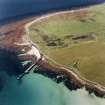
A landing ground sited at Toy Ness where the former Royal Navy pier is located. Records show that aircraft were hauled from the sea using a crane on this pier. There is also a stone built building at this site (HY30SE 7), which may have been utilised by the landing ground.
In addition there a three large concrete shed bases (HY 3505 0490) and two hut bases about 200m SW of Swanbister House (HY22NE 29 and HY30SE 2.00)) which suggests that this was the site of the seaplane base. A large modern shed now stands on one of the concrete bases.
The pier, probable landing strip and shed bases are visible on RAF vertical air photographs (LEU/UK 14, 5078-5079, flown 21 June 1949).
Visited by RCAHMS (DE, GS), August 1999.
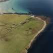
The Smoogroo military air station [AS_LS_04] began life in 1917 as landing ground for wheeled aircraft flown from ships of the fleet in Scapa Flow. It was from Smoogroo that on 2 August 1917 the first aeroplane to be landed on the deck of an aircraft carrier was flown, by Commander Dunning.
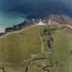
The station occupied an area of 47 hectares which was described in the RAF aerodrome survey of 1918 as ‘very rough and uneven in places’. Modern mapping suggests that much of the area in the NW part of the site is boggy. The aerodrome was equipped with three Bessoneaux canvas hangars, measuring 20m square, located at HY 3518 0454, near the northern edge of the site. The limited number of military personnel were accommodated in a small group of buildings which were not unambiguously marked on the RAF survey map. It may be that existing buildings were reused (mapped on the 1902 2nd edition OS 1:2500 sheet) near the beach, at HY 35438 04492 [HY30SE 7] or that the huts were built in that area. The RAF survey mentions a workshop measuring 18m by 6m, and this may be identified with a stone-built structure, described as 20m long by 8m wide, roofed with asbestos sheeting and with concrete lintels, at HY 35189 04600 [HY30SE 6]. This structure was marked on the 1918 RAF survey map but not on the 1902 OS sheet. The final element of the station was a jetty, at HY 35548 04429, which was equipped with a small crane [HY30SE 2.01].
At the time of the survey (15 November 1918) construction of the aerodrome was incomplete, although it had been fully operational for some time – the buildings of the aerodrome, other than the Bessoneaux hangars, were 75 per cent complete; the jetty was 60 per cent complete, and only three-quarters of the aerodrome area had been cleared.
Work began in 1918 on the construction of three substantial and permanent hangars, which seem to have been intended for the maintenance of large seaplanes. These were located to the north of the aerodrome, at HY 35049 04905. Stell suggests that the base was intended to complement or replace the Houton Bay station. Work continued until 1922-3, when the project was aborted.
Little is visible of the fabric of the base. The jetty and its crane survive, the latter being a rare survival of a First World War artefact; so too does the stone-built workshop and the group of pre-existing buildings. The three concrete bases of the later hangars also survive, one having been re-used as the site of a modern barn.
Information from HS/RCAHMS World War One Audit Project (GJB) 31 May 2013
HY30SE 2.00 35049 04908
HY30SE 2.01 centred HY 3555 0443 Pier
All that could be seen at this location was a large modern concrete base with a recently built agricultural shed on the central pad.
Three large concrete bases are visible on RAF vertical air photographs (LEU/ UK 14, 5078-5079, flown 21 June 1949), at this location, which would suggest there was a diffrent configuration to those visible today. In addition, there is evidence from the photographs of bases for buttresses of a structure of unknown type.
Visited by RCAHMS, (DE, GS), August 1999
Desk Based Assessment (1998)
Located
A WWI seaplane base was located in this area. Not inspected.
Moore and Wilson, 1998
Orkney Coastal Zone Assessment
Project (March 2013 - September 2013)
A project to characterise the quantity and quality of the Scottish resource of known surviving remains of the First World War. Carried out in partnership between Historic Scotland and RCAHMS.

