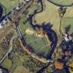
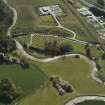
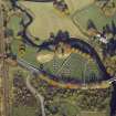
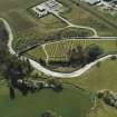
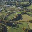
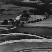
Accessibility

Font Size

100% 150% 200%

Background Colour

Default Contrast
Close Reset

Inverurie Cemetery

Cemetery (19th Century) - (20th Century), War Memorial (19th Century) - (20th Century)

Site Name Inverurie Cemetery

Classification Cemetery (19th Century) - (20th Century), War Memorial (19th Century) - (20th Century)

Alternative Name(s) Old Inverurie; Battle Of Inverurie War Memorial Cairn

Canmore ID 112604

Site Number NJ72SE 138

NGR NJ 7815 2055

NGR Description Centred NJ 7815 2055

Datum OSGB36 - NGR

Permalink http://canmore.org.uk/site/112604

Ordnance Survey licence number AC0000807262. All rights reserved.
Canmore Disclaimer. © Bluesky International Limited 2025. Public Sector Viewing Terms

Toggle Aerial | View on large map

Digital Images

General oblique aerial view of the town, taken from the SE.
General oblique aerial view of the town, taken from the SE.Oblique aerial view centred on the remains of the motte and bailey castle and the cemetery, looking to the NNW.General oblique aerial view centred on the remains of the motte and bailey castle and the cemetery, taken from the NW.Oblique aerial view centred on the remains of the motte-and-bailey castle, burial-ground and the cemetery with the cottage adjacent, taken from the NNE.Oblique aerial view centred on the remains of the motte and bailey castle and the cemetery, taken from the SE.Oblique aerial view centred on the remains of the motte-and-bailey castle, burial-ground and the cemetery with the cottage adjacent, taken from the NNE.Oblique aerial view centred on the remains of the motte and bailey castle and the cemetery, taken from the SSE.Oblique aerial view centred on the remains of the motte-and-bailey castle, burial-ground and the cemetery with the cottage adjacent, taken from the NE.General oblique aerial view centred on the remains of the motte and bailey castle and the cemetery, taken from the NE.View of headstone.The Bass of Inverurie and Inverurie Cemetery.  Oblique aerial photograph taken facing east.  This image has been produced from a print.

Administrative Areas

  • Council Aberdeenshire
  • Parish Inverurie
  • Former Region Grampian
  • Former District Gordon
  • Former County Aberdeenshire

Archaeology Notes

NJ72SE 138 centred 7815 2055

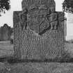
For Pictish Symbol Stones (NJ 7802 2062), Bass of Inverurie (NJ 7809 2059) and Old Inverurie Churchyard (NJ 7800 2064), see NJ72SE 11.00, NJ72SE 13, NJ72SE 15 respectively.

Activities

Project (February 2014 - July 2014)

A data upgrade project to record war memorials.

References

MyCanmore Image Contributions


Contribute an Image

MyCanmore Text Contributions