Accessibility

Font Size

100% 150% 200%

Background Colour

Default Contrast
Close Reset

Glimps Holm Island

Air Raid Shelter(S) (20th Century), Tramway (20th Century)

Site Name Glimps Holm Island

Classification Air Raid Shelter(S) (20th Century), Tramway (20th Century)

Canmore ID 112568

Site Number ND49NE 21

NGR ND 4743 9934

NGR Description Centred on ND 4743 9934

Datum OSGB36 - NGR

Permalink http://canmore.org.uk/site/112568

Ordnance Survey licence number AC0000807262. All rights reserved.
Canmore Disclaimer. © Bluesky International Limited 2025. Public Sector Viewing Terms

Toggle Aerial | View on large map

Digital Images

Oblique aerial view from NE, centred on the Barrier, and showing the wreck of the blockship Elton in the centre left of the photograph, and traces of Air-raid Shelters and a Tramway on Glimps Holm in the top right-hand corner.
Oblique aerial view from NE, centred on the Barrier, and showing the wreck of the blockship Elton in the centre left of the photograph, and traces of Air-raid Shelters and a Tramway on Glimps Holm in the top right-hand corner.Oblique aerial view from E, centred on the Barrier, and showing the wreck of the blockship Elton in the centre left of the photograph, and traces of Air-raid Shelters and a Tramway on Glimps Holm in the top left-hand corner.Oblique aerial view from NNE, centred on the Barrier, and showing traces of Air-raid Shelters and a Tramway on Glimps Holm in the top right-hand corner. Barrier No. 3 is visible in the top half of the photograph.

Administrative Areas

  • Council Orkney Islands
  • Parish South Ronaldsay
  • Former Region Orkney Islands Area
  • Former District Orkney
  • Former County Orkney

Archaeology Notes (May 1996)

ND49NE 21 Centred 4743 9934

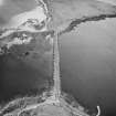
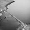
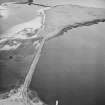
Two air-raid shelters survive on the N-facing slope of Glimps Holm to the SW of the Churchill Barrier (ND49NE 15). One is built of brick, the other brick and concrete. They are likely to have been used by Italian prisoners-of-war who were being used to assist in constructing the Churchill Barriers. Some 150m due E a tramway embankment can be traced running NE towards the barrier where is ends somewhere near the main road.

Visited by RCAHMS (DE) May 1996

References

MyCanmore Image Contributions


Contribute an Image

MyCanmore Text Contributions