
Following the launch of trove.scot in February 2025 we are now planning the retiral of some of our webservices. Canmore will be switched off on 24th June 2025. Information about the closure can be found on the HES website: Retiral of HES web services | Historic Environment Scotland
Backhill


Farmstead (Post Medieval), Sheepfold (Post Medieval)
Site Name Backhill
Classification Farmstead (Post Medieval), Sheepfold (Post Medieval)
Canmore ID 112049
Site Number NN90SW 7
NGR NN 91102 04540
Datum OSGB36 - NGR
Permalink http://canmore.org.uk/site/112049


- Council Perth And Kinross
- Parish Tillicoultry (Perth And Kinross)
- Former Region Tayside
- Former District Perth And Kinross
- Former County Clackmannanshire
NN90SW 7 9108 0453
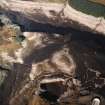
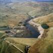
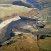
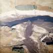
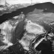
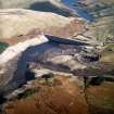
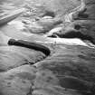
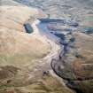
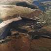
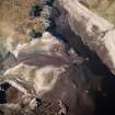
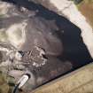
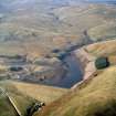
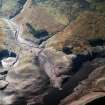
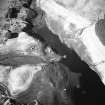
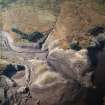
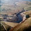
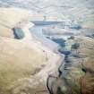
A farmstead and a sheepfold, which are depicted on the 1st edition of the OS 6-inch map (Perthshire 1866, sheet cxxvii), now lie beneath Upper Glendevon Reservoir. The farmstead comprises one roofed building at the N end of an enclosure and is named 'Backhill', whilst the sheepfold consists of one roofed building attached to a sub-divided rectangular fold.
Information from RCAHMS (PM) 16 August 1996
The farmstead and sheepfold that are depicted on the 1st edition of the OS 6-inch map (Perthshire and Clackmannanshire 1866, sheet cxxvii), are also recorded on vertical aerial photography (RAF 106G/SCOT UK 120, frame no.3258, 20 June 1946), which show the roofed farmstead and ancillary structures.
Information from RCAHMS (DCC) 25 March 2002
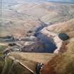
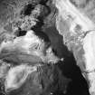
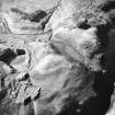
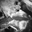
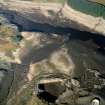
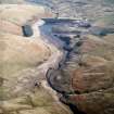
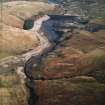
The farmstead and sheepfold are also recorded on oblique aerial photographs (RCAHMSAP 2003), they are now submerged under the Upper Glendevon Reservoir but were recorded during low water levels.
Information from (ALD) 24 May 2004
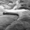
Measured Survey (8 October 2003)
A GPS survey of the archaeology within the area of the Upper Glendevon Reservoir was undertaken by RCAHMS on 8th October 2003. Water levels in the reservoir had fallen substantially over the summer and autumn leaving the sites exposed.

