
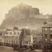
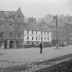
Edinburgh, 6 Grassmarket


Shop (19th Century), Tenement (19th Century)
Site Name Edinburgh, 6 Grassmarket
Classification Shop (19th Century), Tenement (19th Century)
Canmore ID 111839
Site Number NT27SE 640
NGR NT 25299 73348
Datum OSGB36 - NGR
Permalink http://canmore.org.uk/site/111839


- Council Edinburgh, City Of
- Parish Edinburgh (Edinburgh, City Of)
- Former Region Lothian
- Former District City Of Edinburgh
- Former County Midlothian
Desk Based Assessment (12 May 2015 - 13 May 2015)
Addyman Archaeology undertook a desk-based assessment of 4-6 Grassmarket, part of the Category B listed building 4-10 Grassmarket. The assessment was commissioned as part of a project to renovate and expand the church space into a bar/restaurant. It is located in the western end of the Grassmarket and abuts part of the Flodden Wall. The current building was constructed in 1884 as a part of the Robertson Memorial Mission Buildings comprising a church with seating for 220 people and a shop/tenement. Prior to the 17th century the proposed development site consisted of burgage backland area before the expansion of Edinburgh led to the construction of commercial and domestic buildings. The church was in use by the Mission well into the 20th century however it encountered financial difficulties and eventually became an antiques store. In the 1990's it became a sport's bar and later a whiskey bar. Until 2010 it was in use as a restaurant/cafe and events space.
Information from Rachel McMullan (Addyman Archaeology) May 2015.
OASIS ID: addymana1-211273
Archaeological Evaluation (21 September 2015 - 22 September 2015)
NT 25286 73371 A trial trenching evaluation was carried out, 21–22 September 2015, on land to the rear of 4–6 Grassmarket in advance of development of the area as a bar/restaurant and event space.
The excavation of three trenches established the presence of significant late modern demolition deposits to the maximum depth of 1.2m reached during the excavation. A thin band of archaeological deposits was discovered at the northern extent of the site, between the demolition deposits and the southern wall of Dance Base. The artefactual evidence from these deposits suggested they date to the late 19th to early 20th centuries.
It is considered that the demolition deposits were probably generated during the dismantling of buildings and various recent phases of rebuild and repair to the Flodden Wall.
Access to this plot of land is difficult and it seems likely that rubble was heaped to the rear of the site rather than removed. It is thought that in situ archaeological deposits are likely to exist below the depth of the rubble deposit.
Archive: NRHE (intended)
Funder: Signature Pubs Ltd
Andrew Morrison – Addyman Archaeology
(Source: DES, Volume 17)

