
Following the launch of trove.scot in February 2025 we are now planning the retiral of some of our webservices. Canmore will be switched off on 24th June 2025. Information about the closure can be found on the HES website: Retiral of HES web services | Historic Environment Scotland
Drumin


Farmhouse (Period Unassigned), Farmstead (Period Unassigned)
Site Name Drumin
Classification Farmhouse (Period Unassigned), Farmstead (Period Unassigned)
Canmore ID 111782
Site Number NJ13SE 23
NGR NJ 18429 30269
Datum OSGB36 - NGR
Permalink http://canmore.org.uk/site/111782


- Council Moray
- Parish Inveravon
- Former Region Grampian
- Former District Moray
- Former County Banffshire
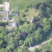
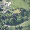
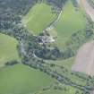
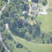
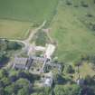
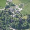
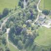
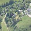
Drumin is a large farmsteading depicted on the current Ordnance Survey map, situated on a prominent bluff at the confluence of the Rivers Livet and Avon. Within its grounds lie the ruins of Drumin Castle.
The 1st edition of the Ordnance Survey 6-inch map of Banffshire (1872) shows that at this date Drumin was a sizeable steading, with its own mill, as a dam and sluice are depicted, evidently in working order.
Text prepared by RCAHMS as part of the Accessing Scotland's Past project
NJ13SE 23.00 1841 3025
NJ13SE 23.01 NJ 1854 3008 Drumin Cottages
For adjacent Drumin Castle tower-house, see NJ13SE 2.

