
Pricing Change
New pricing for orders of material from this site will come into place shortly. Charges for supply of digital images, digitisation on demand, prints and licensing will be altered.
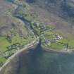
Poolewe, Srondubh


Farmhouse (Period Unassigned)
Site Name Poolewe, Srondubh
Classification Farmhouse (Period Unassigned)
Alternative Name(s) Poolewe, Srondubh House
Canmore ID 111295
Site Number NG88SE 40
NGR NG 86211 81322
Datum OSGB36 - NGR
Permalink http://canmore.org.uk/site/111295


- Council Highland
- Parish Gairloch
- Former Region Highland
- Former District Ross And Cromarty
- Former County Ross And Cromarty
Srp Note (2 November 2011)
Called 'Inverewe' on the 1st ed OS map of 1875, this old farmhouse dates to circa 1730-1740, and probably has an earlier core. The name 'Srondubh' does not appear to have been used until the turn of the century. It is a 2 storey building, white harled with 5 bays. The Steading consisting of the byre and hay barn (NG88SE41) were originally part of the farm complex.
Information from NTS: INVG049 (JH 1998)

