
Pricing Change
New pricing for orders of material from this site will come into place shortly. Charges for supply of digital images, digitisation on demand, prints and licensing will be altered.
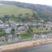
Rosemarkie, Church Place, Rosemarkie Parish Church, Churchyard Wall, Gates And Gate Piers


Churchyard (Period Unassigned), Gate (Period Unassigned), Gate Pier (Period Unassigned), Wall (Period Unassigned)
Site Name Rosemarkie, Church Place, Rosemarkie Parish Church, Churchyard Wall, Gates And Gate Piers
Classification Churchyard (Period Unassigned), Gate (Period Unassigned), Gate Pier (Period Unassigned), Wall (Period Unassigned)
Alternative Name(s) Rosemarkie Churchyard
Canmore ID 111173
Site Number NH75NW 7.07
NGR NH 73693 57616
Datum OSGB36 - NGR
Permalink http://canmore.org.uk/site/111173

- Council Highland
- Parish Rosemarkie
- Former Region Highland
- Former District Ross And Cromarty
- Former County Ross And Cromarty
Note (9 September 2011)
This site record was created to indicate a building which is, or was, listed but for which Canmore holds no supplementary information. Further information on listed buildings is available from http://portal.historicenvironment.scot/
Information from RCAHMS (SC) 9 September 2011

