
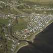
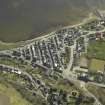
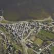
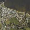
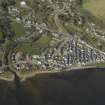
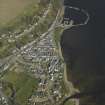
Avoch, Henrietta Bridge


Road Bridge (Period Unassigned)
Site Name Avoch, Henrietta Bridge
Classification Road Bridge (Period Unassigned)
Alternative Name(s) Avoch Village, Henrietta Street, Bridge; Avoch Burn; Fishertown
Canmore ID 111128
Site Number NH75SW 9
NGR NH 70076 54866
Datum OSGB36 - NGR
Permalink http://canmore.org.uk/site/111128


- Council Highland
- Parish Avoch
- Former Region Highland
- Former District Ross And Cromarty
- Former County Ross And Cromarty
NH75SW 9 70076 54866
Henrietta Bridge [NAT]
OS (GIS) MasterMap, November 2009.
Location formerly entered as NH 70077 54865.
This single arched span bridge of dressed rubble was built in around 1830. A splayed parapet was built with the same materials. Said to be built by Hugh Miller.
(Undated) information in NMRS.
Bridge; conservation area - visited.
CFA/MORA Coastal Assessment Survey 1998.
This bridge was built in around 1830 and has a single span and splayed parapet. It was built in dressed rubble, apparently by Hugh Miller. The previous bridge was swept away in a flood in 1829. The bridge links Fishertown with Henrietta Street. The bridge was researched as part of an archaeological desktop and walkover survey ahead of a water main renewal project.
S Farrell 2004.
This bridge carries an unclassified public road over the Avoch Burn on the SW side of Avoch village (NH75NW 94).
Information from RCAHMS (RJCM), 12 November 2009.

