
Stead Inn, Potterton


Enclosure (Period Unassigned), Pit(S) (Period Unassigned), Pit Alignment (Prehistoric)(Possible)
Site Name Stead Inn, Potterton
Classification Enclosure (Period Unassigned), Pit(S) (Period Unassigned), Pit Alignment (Prehistoric)(Possible)
Canmore ID 110711
Site Number NJ91NW 32
NGR NJ 9449 1573
Datum OSGB36 - NGR
Permalink http://canmore.org.uk/site/110711


- Council Aberdeenshire
- Parish Belhelvie
- Former Region Grampian
- Former District Gordon
- Former County Aberdeenshire
NJ91NW 32 9449 1573
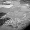
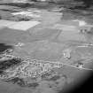
Vertical aerial photography (OS 82/162/034) has revealed the cropmarks of an oval enclosure 130m NNW of the Stead Inn, Potterton. The enclosure measures about 33m from N to S by 27m transversely within a ditch up to 3m in breadth. Within the same field there are a number of pits, at least nine of which appear to form a roughly straight alignment extending from E to W over a distance of about 87m.
Information from RCAHMS (JRS), 18 April 1996.

