
Following the launch of trove.scot in February 2025 we are now planning the retiral of some of our webservices. Canmore will be switched off on 24th June 2025. Information about the closure can be found on the HES website: Retiral of HES web services | Historic Environment Scotland
Loch Of Tingwall


Standing Stone (Prehistoric)
Site Name Loch Of Tingwall
Classification Standing Stone (Prehistoric)
Canmore ID 1106
Site Number HU44SW 13
NGR HU 4124 4203
Datum OSGB36 - NGR
Permalink http://canmore.org.uk/site/1106


- Council Shetland Islands
- Parish Tingwall
- Former Region Shetland Islands Area
- Former District Shetland
- Former County Shetland
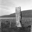
HU44SW 13 4124 4203.
(HU 4124 4202) Standing Stone (OE)
O.S. 1:10,000 1973.
A standing stone set with its major axis approximately NNE - SSW. It rises to a height of 6' 9" above the ground, where there is some evidence of packing and at 3' high it has a girth of 7'.
RCAHMS 1946. Visited 1930.
Standing stone as described.
Published Survey (25") correct.
Visited OS (RL) 7th May 1968.
Publication Account (1997)
This 2m tall stone is located close to the neck of land that separates the two lochs which almost fill the floor of the valley, the Loch of Tingwall to the north and the Loch of Asta to the south.
Information from ‘Exploring Scotland’s Heritage: Shetland’, (1997).

