
Skye, Rubh' An Dunain


Township (Period Unassigned)
Site Name Skye, Rubh' An Dunain
Classification Township (Period Unassigned)
Alternative Name(s) Rudh' An Dunain
Canmore ID 11023
Site Number NG31NE 3
NGR NG 393 160
Datum OSGB36 - NGR
Permalink http://canmore.org.uk/site/11023


- Council Highland
- Parish Bracadale
- Former Region Highland
- Former District Skye And Lochalsh
- Former County Inverness-shire
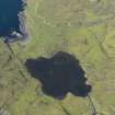
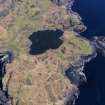
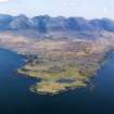
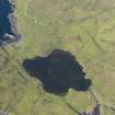
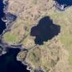
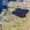
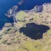
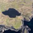
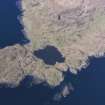
Rubh' an Dunain
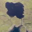
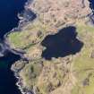
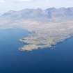
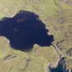
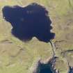
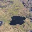
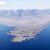
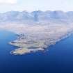
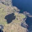
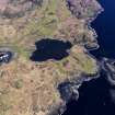
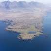
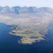
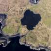
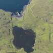
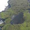
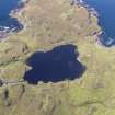
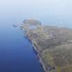
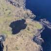
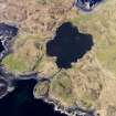
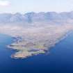
At the toe of this remote promontory, bounded by Loch Brittle and the Sound of Soay and reached only by a lonely track, lies a rich palimpsest of archaeological remains testifying to the former significance of Rubh' an Dunain. Chambered cairn, probably 2nd or 3rd millennium bc, a Neolithic passage grave. To its south, one of best preserved survivals of an Iron Age promontory fort (or galleried dun), with a portion of curved drystone wall to landward, possibly 1st millennium bc. A stone-lined canal, possibly Viking, connects a sheltered inlet to a small lochan, suitable for harbouring birlinns. Small former township, with round-ended ruin of early-mid 18th century tacksman's house, a two-storey chimney gable at one end. Still occupied in the 1860s, this was the home of the MacAskills of Rubh' an Dunain.
[According to tradition, the MacAskills were appointed hereditary keepers of Dunscaith Castle, becoming vassals of the Macleods in the 13th century when Norse rule ended. They held the lands of Rubh' an Dunain in exchange for coast-guarding duties. By the early 19th century, Rubh' an Dunain was part of a vast sheepfarm comprising the whole of South Minginish (including much of Glen Brittle and the Isle of Soay). Indeed, it was Kenneth MacAskill who was responsible for introducing sheep farming to Skye. However, rent increases forced him to emigrate with his people to America in 1811. A descendant, Hugh MacAskill (founder of Talisker Distillery), later farmed Glen Brittle; he was the last of this family to inhabit and farm the peninsula, dying in 1864.]
Taken from "Western Seaboard: An Illustrated Architectural Guide", by Mary Miers, 2008. Published by the Rutland Press http://www.rias.org.uk

NG31NE 3 393 160.
(NG 393 160) Unnamed depopulated area deserted by 1877. (OS 6"map, Inverness-shire, 1st ed., (1877)
Visited by OS (A C) 20 January 1961.
There is a depopulated township scattered about the South Western side of Loch an h-Airde comprising about 4 houses and about 8 smaller buildings. Mr MacAskill (J MacAskill, Drynoch), aged 88 years, formerly of Glen Brittle, considers it probable that it was the settlement of the fishing community who used the loch as a harbour.
Visited by OS (C F W) 9 April 1961.
A township, comprising eight unroofed buildings and one enclosure is depicted on the 1st edition of the OS 6-inch map (Inverness-shire, Isle of Skye 1881, sheet xlix). Nine unroofed buildings and one enclosure are shown on the current edition of the OS 1:10000 map (1986).
Information from RCAHMS (AKK) 14 November 1996.

