
Scheduled Maintenance
Please be advised that this website will undergo scheduled maintenance on the following dates: •
Tuesday 3rd December 11:00-15:00
During these times, some services may be temporarily unavailable. We apologise for any inconvenience this may cause.
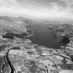
Lochness Cottage


Farmstead (Period Unassigned)
Site Name Lochness Cottage
Classification Farmstead (Period Unassigned)
Canmore ID 109954
Site Number NH31SE 4
NGR NH 3900 1066
Datum OSGB36 - NGR
Permalink http://canmore.org.uk/site/109954

- Council Highland
- Parish Boleskine And Abertarff
- Former Region Highland
- Former District Inverness
- Former County Inverness-shire
Note
A farmstead, comprising one roofed building and one unroofed structure is depicted on the 1st edition of the 6-inch map (Inverness-shire 1874, sheet lxviii). Two roofed buildings are shown on the current edition of the OS 1:10000 map (1971).
Information from RCAHMS (AKK) 3 June 1996.

