
Paitnagreen


Farmstead (Period Unassigned)
Site Name Paitnagreen
Classification Farmstead (Period Unassigned)
Canmore ID 109818
Site Number NH10NE 3
NGR NH 190 065
Datum OSGB36 - NGR
Permalink http://canmore.org.uk/site/109818

- Council Highland
- Parish Urquhart And Glenmoriston
- Former Region Highland
- Former District Inverness
- Former County Inverness-shire
Note
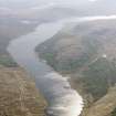
A farmstead comprising an unroofed building with an attached enclosure and a small field is depicted on the 1st edition of the OS 6-inch map (Inverness-shire 1875, sheet lxxxi), but it is not shown on the current edition of the OS 1:10000 map (1971). Due to the damming of Loch Loyne, this site is now under water.
Information from RCAHMS (SAH) 5 June 1996

