
Skye, Trumpan Church


Burial Ground (Medieval), Church (Medieval), Font (Medieval), Grave Slab(S) (Medieval)
Site Name Skye, Trumpan Church
Classification Burial Ground (Medieval), Church (Medieval), Font (Medieval), Grave Slab(S) (Medieval)
Alternative Name(s) Hallin; Trumpan Church, Burial Ground And 'priest's Stone'
Canmore ID 10939
Site Number NG26SW 3
NGR NG 22496 61213
Datum OSGB36 - NGR
Permalink http://canmore.org.uk/site/10939


![1. a) Rubbing of grave slab, St. Clement's Church, Rodel, Harris
b) See alsp rubbing on in/457
[one of these above is Inv.Fig.144]
2. a) Rubbing of grave slab, Trumpan Church, Vaternish, Skye (Parish of Duirnish)
b) See also rubbing on In/657
[One of these above is Inv. Fig. 248]
3. a) Rubbing of grave slab, St. Clement's Church, Rodel, Harris
b) See also Rubbing on IN/457
[One of these above is Inv.Fig.143]](http://i.rcahms.gov.uk/canmore/l/SC01321477.jpg)


![1. a) Rubbing of grave slab, St. Clement's Church, Rodel, Harris
b) See alsp rubbing on in/457
[one of these above is Inv.Fig.144]
2. a) Rubbing of grave slab, Trumpan Church, Vaternish, Skye (Parish of Duirnish)
b) See also rubbing on In/657
[One of these above is Inv. Fig. 248]
3. a) Rubbing of grave slab, St. Clement's Church, Rodel, Harris
b) See also Rubbing on IN/457
[One of these above is Inv.Fig.143]](http://i.rcahms.gov.uk/canmore/s/SC01321477.jpg)


- Council Highland
- Parish Duirinish
- Former Region Highland
- Former District Skye And Lochalsh
- Former County Inverness-shire
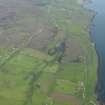
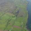
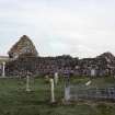
Trumpan. Cille Chonain, medieval, in use until the 16th century. Lichened ruin of St. Conan's church, its long north wall with arched doorway and east gable surviving intact. Once the focus of a medieval village, it stands today in solitude on its windy platform looking out to the slab-like profile of Loch Dunvegan's western headland. Some late medieval carved graveslabs survive - one inside the church depicting a claymore with foliage and animals; another in its encircling walled graveyard depicts a priest, cross and chalice.
[In 1578 a band of Clanranald marauders from South Uist burnt the worshipping MacLeod congregation of Cille Chonain in retribution for the massacre (said to have taken place in 1577) of the entire population of Eigg, suffocated to death while taking refuge in a cave. Fellow Macleods hastened to Ardmore Bay with their charmed fairy flag, and hardly one Macdonald escaped the ensuing slaughter. They were buried by a dyke which was pushed over on top of their corpses, hence the name of this skirmish - The Battle of the Spoiling of the Dyke.]
Taken from "Western Seaboard: An Illustrated Architectural Guide", by Mary Miers, 2007. Published by the Rutland Press http://www.rias.org.uk

NG26SW 3 2249 6121.
(NG 2249 6121) Church (NR) (In Ruins)
OS 6" map, Inverness-shire, 2nd ed., (1904)
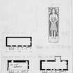
Trumpan Church, now ruinous, orientated E-W and oblong on plan, measures externally 49'9" by 22'10". The N wall stands to a height of about 9' and contains at its W end a small rough arched doorway; only traces of the foundations of the S wall remain. Lying amongst the ruins is a broken stone basin, probably a font. In the churchyard are two late medieval grave-slabs.
Watson (W J Watson 1926) in a very brief reference to St. Connan notes that at Waternish, Skye, there is Cill Chonnain at Trumpan Head. Forbes (A P Forbes 1872) lists S. Conan (ob.648) and notes that he is'honoured amongst the Hebrides' and is said to have been a Bishop of Sodor.
As described above; no further information regarding dedication.
Visited by OS (C F W) 8 January 1961.
A P Forbes 1872; T S Muir 1885; W J Watson 1926; RCAHMS 1928.
Scheduled as Trumpan Church, burial ground and 'Priest's Stone', Hallin.
Information from Historic Scotland, scheduling document dated 12 February 2001.
Field Visit (21 May 1915 - 13 June 1921)
Trumpan Church, Vaternish.
About a quarter of a mile north of Ardmore Bay, and fully 200 feet above sea-level, is Trumpan Church, now ruinous. Orientated and oblong on plan, it measures externally 49 feet 9 inches by 22 feet 10 inches. The north wall, 4 feet 5 inches in thickness and standing to a height of about 9 feet, contains at its west end a small rough arched doorway 2 feet 8 inches wide on the outside checked and splayed inwardly, and at its east end a small window, 7 inches wide and splayed inwardly to 5 feet. A similar window is in the centre of the east gable, which is 2 feet 9 inches in thickness. There is no opening in the west gable, now much decayed, and only traces of foundations of the south wall remain. The church is built of rough rubble.
Lying amongst the ruins is a broken stone basin about 1 foot 2 inches at its widest part and 8 inches thick, having a circular cavity of 9 ½ inches in diameter and 6 inches deep.
CARVED SLABS. In the churchyard at Trumpan are two late medieval grave slabs. The first, of dark schist, is 6 feet 4 inches in length, 17½ inches in breadth at the top, and 14½ inches at the bottom. In a sunk panel under an arabesque canopy is the figure of a bareheaded and possibly tonsured cleric dressed in chasuble and stole, carved in low relief. The hands are placed in front of the breast in the attitude of prayer. The apex of the canopy terminates in a foliaceous design. In the upper part of the stone, within a circle, is an interlaced foliaceous cross, and in the lower part is a long stemmed chalice. A broad flat moulding 1½ inches broad is cut round the edge of the stone. (Fig. 248.)
The second grave stone, measuring 6 feet in length and from 18 to 17 inches in breadth, is pretty much worn. Round the edge is a row of low round bosses between two flat mouldings. In the upper part of the stone is a floriated cross of eight rays, below which is a claymore with straight quillons and a round pommel, terminating in a blunt spike. The ends of the quillons are lozenge-shaped. On either side of the hilt is an animal, from whose tail springs a foliaceous design, which is carried alongside the blade of the sword. The "PRIEST'S STONE" is a rough four-sided monolith standing in the burying ground and measuring 4 feet in height and 6 fee inches in girth. Near the top is a small natural cavity.
FONT. A rough, shapeless hollowed stone is said to be a font. It measures 16 inches long by 13 inches broad by 7 inches thick, and is somewhat triangular with rounded angles. A cavity 9 inches in diameter at the lip and 6 inches in depth is hollowed out on the top towards one side. It is narrower in the bottom than the usual hollow in a knocking-stone.
RCAHMS 1928, visited 21 May 1915; 13 June 1921.
OS map: Skye ix.

