
Following the launch of trove.scot in February 2025 we are now planning the retiral of some of our webservices. Canmore will be switched off on 24th June 2025. Information about the closure can be found on the HES website: Retiral of HES web services | Historic Environment Scotland
Milton, Grain Mill


Lade (Period Unassigned), Mill Pond (Period Unassigned), Sluice (Period Unassigned), Watermill (Period Unassigned)
Site Name Milton, Grain Mill
Classification Lade (Period Unassigned), Mill Pond (Period Unassigned), Sluice (Period Unassigned), Watermill (Period Unassigned)
Canmore ID 108663
Site Number NH35NW 9
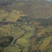
NGR NH 3037 5526
Datum OSGB36 - NGR
Permalink http://canmore.org.uk/site/108663


- Council Highland
- Parish Contin
- Former Region Highland
- Former District Ross And Cromarty
- Former County Ross And Cromarty
Srp Note (14 January 2011)
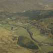
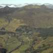
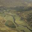
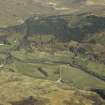
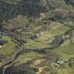
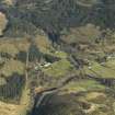
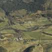
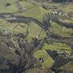
Mills, lades, ponds and sluices (NOSAS site survey Nos 1145 – 1157) - centred on NH303 554 (Grain mill, site 1157, - Nmrs No NH35NW 009) These features extend over a linear area of 800m on the east bank of the Allt Mor, a large burn that drops steeply down to the River Meig in a series of waterfalls. The area has forestry plantation in its upper part, and is overgrown with rhododendrons and thick undergrowth. There are several phases of water management represented by the courses of two lades and two mill ponds, with at least four sluices. Evidence of 4 mills has been found. The mill (site 1157), pond (site 1150) and lade (site 1149) are marked on the 1st edition OS map of c1870 and also on an estate map of c 1853 and a specification, dated 1851, for the construction of a mill replacing an existing one has been located in NAS - GD433-3-3-6.
The mill/wheel pit (site 1152), pond (site 1150) and lade (site 1146) are marked on the current OS map as “sawmill”.
An earlier mill is depicted on the 1825 estate plan in the position of the building, 1145.
1145 Possible Mill - NH 30121 55500 A rectangular platform immediately above and just 4m from the main burn. It is rectangular, on a N-S alignment and 7m x 4m. At the NW corner there is a free standing crudely built piece of wall, 1m in height. The remains of the N wall have stone footings 0.4m high and of 1m spread. The E wall is slightly recessed into the slope; the course of the old lade, 1149, runs parallel just 2m distant. The whole site has been planted with trees. This may be marked on an 1825 plan of the estate as “mill”
1146 Lade - NH 30120 55527 (NW end) to NH 36267 55445 (SE end) The most recent of the two lades is substantially built but grossly overgrown with rhododendrons. It has a NW-SE curving course and is c350m in length. For much of its length it is stone lined (bottom and sides); at the NW end it is 0.8m deep x 1m width. It enters the mill pond, 1150, at its SE end.
1147 Sluice - NH 30125 55531 Two sections to this wooden and iron sluice are hidden in the rhododendrons. One section controls the water into the lade, 1146, and one controls the water into the spillway back into the burn; this initially takes the course of the old lade, 1149, and after a few metres turns abruptly down to the main burn. The sluice here is 1.5m in width.
1148 Dam - NH 30120 55527 (E end) A stone faced dam 2m in height and c25m in length across the main burn appears to have had at least two phases. At its east end a length of concrete “wall” 0.7m high x 0.7m thick which rises above the present level of the dam wall may represent the old dam and may have extended right across. The lade 1146 penetrates it at the east end. The top edge of the dam over which the water runs is 2.5m thick and faced on its upper edge with stones which deflect the water into the lade.
1149 Lade - NH 30120 55527 (NW end) The older of the two lades has a NW to SE course. It is c800m in length and on the lower side of the track. For most of its upper course it descends quite steeply and is an overgrown dry ditch which is as much as 1m deep in places. In the lower part it is fed by a small burn and the “tail race” from the pond, 1150. A sluice, 1155, has controlled the water before it enters the mill pond 1154, ducting it off down a spillway to the west of the pond; this now takes the majority of the water
1150 Mill pond - NH 36267 55430 A small rectangular pond is c 40m x 20m in dimensions. It is entirely artificial and has a large earth bank retaining it on its west and south sides, which is heavily overgrown with rhododendrons and vegetation. At the SE corner there is a substantial sluice
1151 Sluice - NH 30279 55428 A largely intact substantial sluice with stone and concrete retaining walls 1.5m high and with wooden gate, 1m height x 0.8m width in place.
1152 Waterwheel pit - NH 30286 55402 A rectangular pit constructed over the course of the outlet of the pond just a few metres to the south of sluice, 1151. It is c14m in length x c1.7m in width x 2.5m deep. At its north end the retaining wall slopes and rises a further c1.8m above this level (a grid has been placed over this area presumably for safety reasons) Two bolts are seen in the top of the east wall (these may have supported the wheel) A concrete wall, 1.8m high, divides off the deeper north end of the pit, so that the water is retained and it may be that this is a more recent alteration made in connection with a trout hatchery nearby.
1153 Building - NH 30250 55402 A wooden building with a tin/corrugated iron roof in quite good state of repair. Most recently used as a trout hatchery, the tanks are still in place inside.
1154 Mill Pond - NH 30385 55292 The lower of the 2 ponds and the older according to the maps. It is about 80m in diameter but difficult to assess as it is so heavily overgrown. It is retained by an earth bank in its southern half; this may have been constructed by enhancing a natural knoll
1155 Sluice - NH 30377 55318 The remains of this iron and wooden sluice are very wasted.
1156 Sluice - NH 30381 55272 A wooden sluice at the south side of the mill pond. May have been a part of a modern reconstruction associated with the former grain mill, 1157, just a few metres to the south. The remains of a plywood chute are seen in the undergrowth between the two.
1157 Grain Mill (Figure 13) - NH 30371 55258 (Nmrs No NH35NW 009) A building in good state of repair on the north side of the present motor road. It has been renovated and is now used as a picnic place and display centre. It is on a NW-SE alignment and has a wheel pit 0.5m width x 4m length x 0.5m deep along its SE end, the entry point of the axle can be seen in the wall of the building as a blocked up square stone setting.

