
Hewelts Of Kennethmont, New Bridge


Road Bridge (Period Unassigned)
Site Name Hewelts Of Kennethmont, New Bridge
Classification Road Bridge (Period Unassigned)
Alternative Name(s) Howets Of Kennethmont; Roadside Of Cults; Water Of Bogie
Canmore ID 107689
Site Number NJ53SW 27
NGR NJ 52688 31372
Datum OSGB36 - NGR
Permalink http://canmore.org.uk/site/107689

- Council Aberdeenshire
- Parish Kennethmont
- Former Region Grampian
- Former District Gordon
- Former County Aberdeenshire
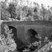
Howets of Kennethmont Bridge, 1852-4, also Alexander Gibb: solid double bridge in coursed rubble carrying main road over railway and Water of Bogie.
Taken from "Aberdeenshire: Donside and Strathbogie - An Illustrated Architectural Guide", by Ian Shepherd, 2006. Published by the Rutland Press http://www.rias.org.uk

NJ53SW 27 52688 31372
For adjacent pillbox and predecessor bridge, see NJ53SW 26 and NJ53SW 86 respectively.
(Name cited as Howets of Kennethmont and location as NJ 527 313). This bridge was built in 1852-4 by Alex. Gibb and carries a public road (now the A979) across both the (Inverness-Aberdeen) main line of the Great North of Scotland Rly (to the E) and the Water of Bogie (to the W). It is of coursed rubble construction and has a semi-elliptical arch over the railway and one of semi-circular form over the river; the central buttresses are broad and battered.
NMRS, MS/712/11.
The Water of Bogie here forms the boundary between the parishes of Rhynie and Kennethmont.
Information from RCAHMS (RJCM), 13 November 2000.

