
Kilcreggan, South Ailey Road


Anti Aircraft Battery (20th Century), Military Camp (20th Century)
Site Name Kilcreggan, South Ailey Road
Classification Anti Aircraft Battery (20th Century), Military Camp (20th Century)
Alternative Name(s) An3; Clyde Aa Defences; Hamlet Hill
Canmore ID 107525
Site Number NS28SW 27
NGR NS 22468 81613
NGR Description Centred NS 22468 81613
Datum OSGB36 - NGR
Permalink http://canmore.org.uk/site/107525


- Council Argyll And Bute
- Parish Rosneath
- Former Region Strathclyde
- Former District Dumbarton
- Former County Dunbartonshire
NS28SW 27 Centred 22468 81613
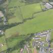
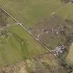
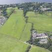
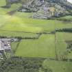
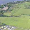
A heavy anti-aircraft battery with associated military accommodation camp has been recorded from Public Record Office papers, immediately to the NW of South Ailey farm. The military camp, of which some remains are still depicted on the OS 1:10000 map (1993) are to the SW.
Information from J Guy 1997
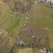
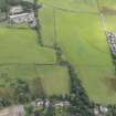
This heavy anti-aircraft position probably mounted the full battery of eight gun-emplacements, with the GL mat (false radar horizon) area located to the NE. One four gun battery was situated to the N of South Ailey Road, the other to the S. The military camp was to the SW.
Information from RCAHMS (DE) July 1997
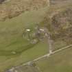
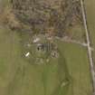
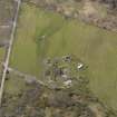
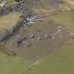
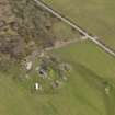
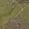
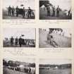
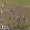
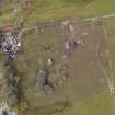
This World War II heavy anti-aircraft battery is situated on the N side of South Ailey Road and the accommodation camp is on the S side. Four gun-emaplacements, command post, remains of magazines survive with parts of the camp also extant.
Records show that the battery only mounted 4 3.7-inch guns.
J Guy 2001; NMRS MS 810/11, Part 2, 121-2, Vol.2 (appendix), 9
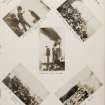
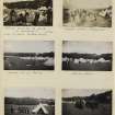
The battery is visible on large scale (approx 1:5800) vertcial air photographs (CPE/Scot/350, 5135-5137, flown 17 April 1948), which show that that the Gl-mat was under demolition at that time. Visible are the four emplacements, command position, magazines and accommodation camp. The camp consists of at least 37 extant huts, mostly of the Nissen type and seven hut bases.
Immediately to the E of the accommodation camp and visible on the air photographs is what appears to be a dummy anti-aircraft battery. Three emplacements with what may be a partly demolished fourth with a command centre with built tracks leading to them can be clearly seen in the field.
Information from RCAHMS (DE), August 2005
The anti-aircraft battery is visible on oblique air photographs (RCAHMS 2008), which clearly show the four gun emplacements and remains of the accommodation camp. Traces of the three dummy or additional emplacements can be seen on the photographs covering the camp area.
Information from RCAHMS (DE), June 2008
Measured Survey (2016)
NS 22478 81617 The site of a WW2 heavy anti-aircraft gun installation was surveyed in 2016. Four gun positions are arranged in an arc around an underground command post and surrounded by a perimeter fence, all are well preserved. A large 130m diameter platform nearby was the position of a radar mat installation. An adjacent camp area consists of the remains of 23 buildings, 5 of which survive nearly completely with metal framed windows in situ. The project is part of a complete survey of military remains along the N Clyde Estuary coastline.
Report: NRHE, WoSAS and on www.spanglefish.com/
NorthClydeArchaeologicalSociety/index.asp
Sandra Kelly – North Clyde Archaeological Society
(Source: DES, Volume 17)

