
Pricing Change
New pricing for orders of material from this site will come into place shortly. Charges for supply of digital images, digitisation on demand, prints and licensing will be altered.
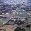
Kemnay


Village (Period Unassigned)
Site Name Kemnay
Classification Village (Period Unassigned)
Canmore ID 107514
Site Number NJ71NW 37
NGR NJ 732 162
Datum OSGB36 - NGR
Permalink http://canmore.org.uk/site/107514


- Council Aberdeenshire
- Parish Kemnay
- Former Region Grampian
- Former District Gordon
- Former County Aberdeenshire
KEMNAY. The village, enchantingly set on the broad Don, with Bennachie before, developed in two, widely separated bursts; the first the opening up of the granite quarries and the coming of the railway in the mid-19th century, prior to which it had been 'a paltry hamlet' (Groome), the second the oil related expansion of the 1970s and 1980s. Kemnay was the granite core of Aberdeenshire, with quarries at Paradise, Leschangie and Whitestones. Now augmented by many different styles of timber housing - two-storey, semi-detached, dark browns and muted greens of Fraser Place to the blithe red and dun cabin-styles by the river
Taken from "Aberdeenshire: Donside and Strathbogie - An Illustrated Architectural Guide", by Ian Shepherd, 2006. Published by the Rutland Press http://www.rias.org.uk


