
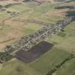
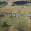
Tomintoul, General


Village (Period Unassigned)
Site Name Tomintoul, General
Classification Village (Period Unassigned)
Canmore ID 107409
Site Number NJ11NE 37
NGR NJ 1683 1869
NGR Description Centred on NJ 1683 1869
Datum OSGB36 - NGR
Permalink http://canmore.org.uk/site/107409


- Council Moray
- Parish Kirkmichael (Moray)
- Former Region Grampian
- Former District Moray
- Former County Banffshire
The village of Tomintoul is generally thought to have been founded in 1750 by Alexander, fourth Duke of Gordon, but in fact the initial surveys were carried out in 1775. The first tenants moved in during 1780.
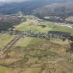
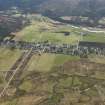
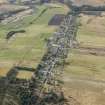
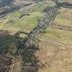
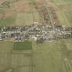
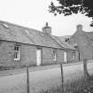
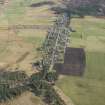
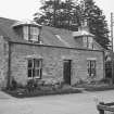
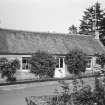
The village was laid out along the military road which had been built between Fort George and Corgarff a few decades earlier, in a location which makes it the highest village above sea level in Highland Scotland. Each plot of land was unusually broad, measuring approximately 22m as opposed to 14m. As a result, many of the cottages were built with an extra outbuilding or an additional 'half-house' at the side. Some of these half-houses, which were often used to house elderly relatives, can still be seen.
In 1792, there were only 37 families in Tomintoul. The local minister noted that they all sold whisky, and that they all drank it, too. Other than this, they supplemented their income by manufacturing odd items or offering their services as casual labour. By 1831, the Duke of Gordon had implemented improvements in agriculture and animal husbandry, and had encouraged the growth of the village. His encouragement paid off: Tomintoul's population had by then risen to 143 families.
In 1853, Queen Victoria described Tomintoul as a 'tumbledown, miserable, dirty-looking place'. A century later, the village had been transformed. The water supply was upgraded in 1890, coal replaced peat as the major domestic fuel by 1920, and in 1949 electricity was introduced. By that time, Tomintoul was already able to hold its own as a popular tourist destination.
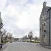
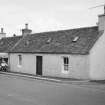
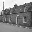
Of the residential buildings in the village, only a few of the original single-storeyed eighteenth-century cottages remain substantially unaltered, most having been subject either to alteration or rebuilding in the later nineteenth century. Three generations of a local family of masons, the Stewarts, were particularly involved in this work. Much of this rebuilding work took place towards the end of the nineteenth century and into the early years of the twentieth century, and many of the town's existing commercial and residential buildings date to this phase. Characteristics of buildings of this period include pedimented upper floor windows, plain gable copes and coursed rubble facades with dressings, usually granite. Large pieces of dressed stone, often granite, may be used as lintels over doorways and windows.
Text prepared by RCAHMS as part of the Accessing Scotland's Past project
Note (August 2017)
Why Tomintoul? High hopes never quite fulfilled
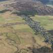
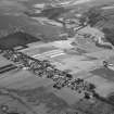
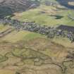
To many of us, the name Tomintoul is most familiar from the memorable words of radio traffic bulletins, announcing the arrival of winter: “The snowgates on the A939 Tomintoul to Cock Bridge are closed”. Some have also heard that it is the highest village in the Highlands, but the question I am most frequently asked is, “Where is Tomintoul?” Well, it is in Strathavon, a district nestled into the northern edge of the Cairngorms, through which the River Avon rushes down to join the Spey at Ballindalloch. The strath, and neighbouring Glenlivet, together present a district of stunning scenery: rolling hills, deep river gorges, agriculture and forestry, ringed by mountainous ranges (the Cairngorms to the south, the Cromdale Hills to the west, and Ben Rinnes and the Ladder Hills to the east) that serve to conceal it from most travellers, even today. Here, in 1775, the Duke of Gordon chose a ridge of moorland as the site for a new village. But, I am asked, why?
The second half of the 18th century was a time of rapid change in the economy of the Highlands. Large areas were turned over to sheep farming, displacing thousands of tenants and their families. Often, they moved south to find work in the rapidly-growing towns of lowland Scotland; but many landowners encouraged their tenants to stay by constructing new towns and villages that were to provide a workforce for new industries, a focus for markets and employment for tradesmen. This was a very bold idea. Apart from a few ancient burghs gathered around cathedrals and castles (such as Elgin and Inverness), urban communities were almost unknown in the Highlands; instead, farming communities were clustered into tiny settlements (‘bailtean’ in Gaelic). Now, new towns and villages were laid out by professional surveyors, all sharing the regular, geometric, plan characteristic of the Georgian period. Some 500 new settlements were founded around Scotland, many of them in the Highlands, and the 4th Duke of Gordon was an enthusiastic builder, responsible for Tomintoul, Fochaber, Kingussie, Portgordon and a rebuilt Huntly.
Tomintoul was sited on a new road, constructed in 1754 by the army to link their state-of-the-art Fort George (near Inverness) with outposts in upland Aberdeenshire. In the years after Culloden, the road was envisaged as part of the government’s insurance against another Jacobite rising. The Duke of Gordon saw it instead as an opportunity to encourage trade, offering a link to markets in the south, and the new village was intended as a centre of the linen industry. It didn’t quite work out. The planned linen mill was never built, and development was slow. Queen Victoria, famously, was most uncomplimentary about Tomintoul on a visit in 1853. This, however, is the key to its importance today. In many cases, the new villages prospered through the 19th century, and have expanded far beyond their original boundaries, disguising their character; others foundered and have all but vanished. Tomintoul sits between these extremes, offering us one of the best-preserved examples of Georgian planning in the Highlands, its layout scarcely changed from the plans drawn up 240 years ago by Thomas Milne, the Duke’s surveyor.
Tomintoul and Glenlivet: religious minorities in a hostile world
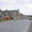
The village straddles the broad Main Street, its houses almost all fronting directly onto it (gardens are to the rear: no ostentatious display here!) At the centre is the spacious Square, flanked by rows of cottages (some dating back two hundred years) and two large Victorian hotels. Perhaps the most interesting aspect of the village, though, is the position of its churches. The Gordons of Huntly remained a resolutely Catholic family in fiercely Presbyterian Scotland, and their religious influence can be seen throughout their estates. In Tomintoul the tension between the two traditions is laid bare. To the north of the square, at the lower end of the town, is the Church of Scotland, built in 1826-27 and one of Thomas Telford’s celebrated ‘Parliamentary’ churches. The manse (also a Telford design) is next door, and the Protestant school was established here too. Up the hill, south of the square, stands the Catholic Church of Our Lady and St Michael, built ten years after its rival, and next door, it too had its school. Divisions have long since blurred and healed, of course, but they remain commemorated here in the very geography of the town.
The resilience of Catholicism is also plain to see in the wider district, especially towards Glenlivet, where impressive churches are found at Tombae and Chapeltown. And it is in Glenlivet that we find one of the most remarkable monuments of Catholic resilience. At the top end of the glen, in a hidden corner of this hidden landscape, stands Scalan, an attractive Georgian house and once a secretive college, where the sons of Catholic gentry were trained as priests. In 1714 a Catholic seminary was discretely established on an island in Loch Morar, on the west coast of Scotland, but it was forced to close down after the failure of the 1715 Jacobite Rising. It was re-established here in Glenlivet, presumably with the tacit consent of the Duke of Gordon. The college was burned to the ground by government troops in the weeks after Culloden, but teaching continued. The building we see today dates from 1769. It became a farmhouse when the college moved to Aberdeenshire in 1799, but it has now been restored as a museum, offering a wonderfully atmospheric recreation of the austere life of teachers and pupils alike. Go there, learn, and marvel!
Eve Boyle - Communities Liaison Manager

