
Pricing Change
New pricing for orders of material from this site will come into place shortly. Charges for supply of digital images, digitisation on demand, prints and licensing will be altered.
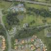
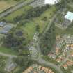
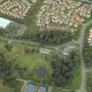
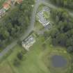
Dunfermline, Pitreavie Castle, Steading


Farmstead (18th Century), Stable(S) (18th Century)
Site Name Dunfermline, Pitreavie Castle, Steading
Classification Farmstead (18th Century), Stable(S) (18th Century)
Alternative Name(s) Raf Pitreavie Castle
Canmore ID 107089
Site Number NT18SW 9.20
NGR NT 11812 84911
Datum OSGB36 - NGR
Permalink http://canmore.org.uk/site/107089


- Council Fife
- Parish Dunfermline
- Former Region Fife
- Former District Dunfermline
- Former County Fife
NT18SW 9.20 11821 84912
Much of the former steading was used as the RAF Other Ranks? social centre (?The White Bear Club?).
Information from Lieutenant Commander RJC Mowat RNR, 9 September 1996.
NT 1183 8491 Stables, 1890s.
Full details are contained in a report lodged with the NMRS.
Sponsor: Ironside Farrar Environmental Consultants at the request of Fife Enterprise.
T Neighbour 1997
see NT18SW 9.00 Pitreavie Castle
Archaeology Notes - for list of related sites

