
Drone Hill, Chain Home Radar Station


Radar Station (20th Century)
Site Name Drone Hill, Chain Home Radar Station
Classification Radar Station (20th Century)
Canmore ID 105960
Site Number NT86NW 70
NGR NT 84533 66679
NGR Description Centred NT 84533 66679
Datum OSGB36 - NGR
Permalink http://canmore.org.uk/site/105960


- Council Scottish Borders, The
- Parish Coldingham
- Former Region Borders
- Former District Berwickshire
- Former County Berwickshire
NT86NW 70.00 centred 84533 66679
NT86NW 70.01 NT 8462 6651 Building (Transmitter [Tx] block)
NT86NW 70.02 NT 8414 6673 Building
NT86NW 70.03 NT 8453 6668 Building; Bunker
NT86NW 70.04 NT 84184 66592 Pillbox
NT86NW 70.05 NT 84058 66724 Pillbox
NT86NW 70.06 NT 84135 66839 Pillbox
NT86NW 70.07 NT 84483 66583 Pillbox
NT86NW 70.08 NT 84684 66579 Pillbox
NT86NW 70.09 NT 84905 66525 Pillbox; Building
NT86NW 70.10 NT 84814 66405 Pillbox
NT86NW 70.11 NT 84647 66377 Pillbox
NT86NW 70.12 NT 84977 66335 Pillbox
NT86NW 70.13 NT 83889 66152 Pillbox
NT86NW 70.14 NT 84779 66962 Pillbox
NT86NW 70.15 c.NT 8501 6706 Bunker
Drone Hill Chain Home radar station is visible on a Luftwaffe aerial photograph taken in 1939.
Information from RCAHMS (KM) 12 August 1996.
Chain Home Low radar station, transmitter block at NT 8462 6651.
Information from I Brown, November 1998
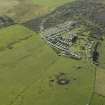
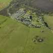
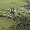
This radar station is situated at Highview Caravan site, W of Huxton, on the S side of the A1107 public road. Many of the buildings are extant along with several Type 27 pillboxes. The transmitter block is now the Bunker Bar. This was a Chain Home Radar station. The property is now owned by Mr W Howard and D Steedman who reside in the former Officers Quarters.
J Guy 1999; NMRS MS 810/8 52-3, P7-8
This Chain Home and Chain Home Low radar station is visible on RAF post-war low level oblique air photographs, (SOP 136, 30-1, flown 14 April 1954) and shows that at this date eight masts still stood to the SW of Drone Moss. In addition, the transmitter blocks (Tx) and other structures are also visible including several of the defensive pillboxes, all of which would appear to be of the air defence type 27.
This radar station was one of the first to be in action during World War II when Luftwaffe raided the Firth of Forth in October 1939, but the station was non-operational at the time due to a technical fault. The site is now a caravan park and the S end has been landscaped to accomodate several caravan bays. The site is notable for a defensive screen of eleven pillboxes several of which are still standing.
Information from RCAHMS(DE), February 2002
This station was never a Chain Home Low radar station, the transmitter block at NT 8462 6651 is a CH block.
Information via e-mail from Mr I Borwn to RCAHMS, 21 October 2005
Sbc Note
Visibility: Upstanding structure, which may not be intact.
Information from Scottish Borders Council.

