
Pricing Change
New pricing for orders of material from this site will come into place shortly. Charges for supply of digital images, digitisation on demand, prints and licensing will be altered.
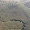
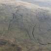
Robert Law, Chapel


Farmstead (Period Unassigned), Field Boundary(S) (Period Unassigned), Rig And Furrow (Medieval) - (Post Medieval)
Site Name Robert Law, Chapel
Classification Farmstead (Period Unassigned), Field Boundary(S) (Period Unassigned), Rig And Furrow (Medieval) - (Post Medieval)
Alternative Name(s) Craig Burn
Canmore ID 105472
Site Number NS83SE 22
NGR NS 8760 3270
Datum OSGB36 - NGR
Permalink http://canmore.org.uk/site/105472


- Council South Lanarkshire
- Parish Douglas
- Former Region Strathclyde
- Former District Clydesdale
- Former County Lanarkshire

