
Harris, Northton


Cairn(S) (Prehistoric), Cist(S) (Bronze Age), Enclosure(S) (Prehistoric)(Possible), Hut Circle(S) (Prehistoric)(Possible), Inhumation(S) (Bronze Age), Midden(S) (Prehistoric), Pin (Bone)(Bronze Age), Unidentified Pottery (Bronze Age)
Site Name Harris, Northton
Classification Cairn(S) (Prehistoric), Cist(S) (Bronze Age), Enclosure(S) (Prehistoric)(Possible), Hut Circle(S) (Prehistoric)(Possible), Inhumation(S) (Bronze Age), Midden(S) (Prehistoric), Pin (Bone)(Bronze Age), Unidentified Pottery (Bronze Age)
Canmore ID 10504
Site Number NF99SE 4
NGR NF 970 914
Datum OSGB36 - NGR
Permalink http://canmore.org.uk/site/10504


- Council Western Isles
- Parish Harris
- Former Region Western Isles Islands Area
- Former District Western Isles
- Former County Inverness-shire
NF99SE 4 970 914.
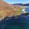
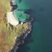
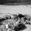
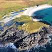
(Area NF 970 915) Evidence of settlement is apparent among the sandhills on the neck of the Rudh 'an Teampull promontory to the N of the church An Teampull (NF99SE 6), the whole area being littered with shells, unornamented hand-made pottery and occasional animal bones. The area contains a grave (5ft 2ins x 1ft 6ins) formed by stone slabs set on edge, within which were found a few skeletal remains. Circular heaps of stones (12ft diameter x 1ft high) resembling cairns; a group of structures consisting of a circular setting of stones (9ft diameter), like a hut circle; a circular ring of stones (4ft 3ins diameter) with an inch-thick dark layer at foundation level; and another circular ring containing only clean sand. On the edge of a sandhill area (34 x 13ft) with rounded corners outside the S corner of which is blackened sand indicating a fire-place.
RCAHMS 1928.
Little is now to be seen in this area of dunes, centred at NF 9700 9144, except a few small mounds, resembling clearance heaps, in a hollow, and what is probably the 'grave' described by the Commission. This latter, at NF 9697 9145, is defined by eleven small stones on edge, and is oriented N-S. There is no sign of skeletal remains and the setting bears little resemblance to a cist or later grave.
There are traces of cultivation both within and with- out the wall which spans the headland to the S, but this is probably fairly recent. (See NF99SE 6 for possible association with chapel and broch site)
Visited by OS (A A) 3 July 1969.
Field Visit (9 June 1914)
Cairns, Graves and Enclosures, Rudh'an Teampuill.
Among the sandhills on the neck of the Rudh' an Teampull promontory, to the north of the church An Teampull [NF99SE 6], are considerable wind-swept areas littered with shells and occasional animal bones. In places circular heaps of stone up to 12 feet in diameter and 1 foot in height resembling small cairns, as well as other settings of stone including a grave and hut circles, have been exposed. The grave measures 5 feet 2 inches in length and 1 foot 6 inches in breadth, and is formed by small slabs less than 1 foot in length and about 1 foot in height set on end nearly touching, four on one side and five on the other, with a single stone at each end. The main axis of the grave lies slightly west of north and east of south (170° mag.) and it contains a few portions of a human skeleton, two small pieces of the skull and several sections of the long bones not exceeding 6 inches in length being recognisable. Near each end of the grave was a shapeless mass of stones. A group of structures in an adjoining wind-swept area showed a circular ring of stone, 4 feet 3 inches in diameter at the top, sloping inwardly for a depth of about 1 foot, from the west-south-west edge of which two rows of small flat stones seton edge and 14 inches apart extended for a distance of 3 feet 9 inches. Some 4 feet to the south-south-east of the circular structure was a circular setting of stones like a hut circle with an internal diameter of 9 feet, and about 6 feet to the west was a similar structure 11 feet in diameter. To the north was a second circular ring of small flat stones set on edge measuring 4 feet in diameter. Nothing but clean sand was found within this structure, but in the first a dark layer about one inch thick was found about the level of the foundation of the structure. (Fig. 97.)
On the edge of a sand hill towards the east side of the peninsula is a somewhat rectangular area with rounded corners enclosed by a line of small boulders. Along the main axis which runs almost north-west and south-east it measures 34 feet, while it is 13 feet broad. A curvilinear setting of similar stones is visible round the ends of the enclosure set at a distance of 7 feet from the north-west end and10 feet from the south-east end. Outside the southern corner a layer of blackened sand indicated the position of a fire-place.
Fragments of unornamented hand–made pottery are found scattered over the greater part of the shell-covered area.
RCAHMS 1928, visited 9 June 1914
OS map: Harris xvii (unnoted).
Note (2020)
Northton
This burial site in Western Isles was a focus for funerary practices in the Bronze Age period, between 2450 BC and 801 BC.
Prehistoric Grave Goods project site ID: 60059
CANMORE ID: 10504
Total no. graves with grave goods: 3
Total no. people with grave goods: 4
Total no. grave goods: 3
Prehistoric Grave Goods project Grave ID: 60028
Grave type: Cist
Burial type(s): Inhumation, Inhumation
Grave good: Pin (Unknown/Unspecified)
Materials used: Bone/Antler/Horn/Ivory/Tooth (Animal) [Bone]
Current museum location: Unknown
Prehistoric Grave Goods project Grave ID: 72326
Grave type: Cist
Burial type(s): Inhumation
Grave good: Pot (Unknown/Unspecified)
Materials used: Pottery
Current museum location: Unknown
Prehistoric Grave Goods project Grave ID: 72327
Grave type: Cist
Burial type(s): Inhumation
Grave good: Pot (Unknown/Unspecified)
Materials used: Pottery
Current museum location: Unknown
Further details, the full project database and downloads of project publications can be found here: https://doi.org/10.5284/1052206
An accessible visualisation of the database can be found here: http://blogs.reading.ac.uk/grave-goods/map/

