
Scheduled Maintenance
Please be advised that this website will undergo scheduled maintenance on the following dates: •
Tuesday 3rd December 11:00-15:00
During these times, some services may be temporarily unavailable. We apologise for any inconvenience this may cause.
Naast


Agricultural Boundary (Period Unknown), Clearance Cairn (Period Unassigned), Croft (Period Unassigned), Cultivation Remains (Period Unassigned), Enclosure (Period Unassigned), Head Dyke (Post Medieval), Hut Circle (Prehistoric), Rig And Furrow (Medieval) - (Post Medieval), Township (Period Unassigned)
Site Name Naast
Classification Agricultural Boundary (Period Unknown), Clearance Cairn (Period Unassigned), Croft (Period Unassigned), Cultivation Remains (Period Unassigned), Enclosure (Period Unassigned), Head Dyke (Post Medieval), Hut Circle (Prehistoric), Rig And Furrow (Medieval) - (Post Medieval), Township (Period Unassigned)
Alternative Name(s) Naust
Canmore ID 105018
Site Number NG88SW 9
NGR NG 826 833
NGR Description centred on NG 826 833
Datum OSGB36 - NGR
Permalink http://canmore.org.uk/site/105018


- Council Highland
- Parish Gairloch
- Former Region Highland
- Former District Ross And Cromarty
- Former County Ross And Cromarty
NG88SW 9 centred on 826 833
A crofting township comprising twenty-six roofed, one partially roofed, nine unroofed buildings, five enclosures and some field walls is depicted on the 1st edition of the OS 6-inch map (Ross-shire 1881, sheet xxxii). Eighteen roofed buildings, one of which is circular and labelled as a tank, one partially roofed building, twenty unroofed buildings, three enclosures and some field walls are shown on the current edition of the OS 1:10560 map (1968).
Information from RCAHMS (SAH) 18 April 1996
Field Visit (26 April 2008 - 21 July 2010)
SRP Naast - Township survey
Reference (26 April 2008 - 21 July 2010)
SRP Naast - Historical documents research
Srp Note (20 September 2011)
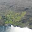
The crofting township of Naast lies on the west shore of a sheltered sea loch, Loch Ewe, centred on NG 826 833. The township faces NE on a sloping hillside which rises from the shore of Loch Ewe to an elevation of about 100 m. Much of the township is on a slope of approximately 1:5 gradient, but on some parts can be much steeper. Several burns flow through the settlement and enter the sea, where there is a Second World War jetty and other older boat landings on the shore. The public road from Poolewe to Inverasdale runs SE to NW through the township, bisecting several crofts.
A detailed survey of township was undertaken during 2008-2010 by Loch Ewe Heritage Group as part of the Scotland’s Rural Past project, involving archaeological fieldwork and historical research. Surveys revealed 22 roofed, 25 unroofed buildings, 5 hut circles, 2 enclosures and numerous remains of dykes and enclosures.
The present-day township consists of 12 crofts created by the Gairloch Estate in 1845 and set out on a square grid. Naast, however, is a multi-period site, with the 1845 crofts being superimposed on a pre-improvement township. There are 5 hut circles within or adjacent to the township, as well as the remains of buildings from the pre-improvement township and contemporary field boundaries and head dykes, suggesting that the site has been occupied from the prehistoric period. The distribution of all the surveyed buildings and features is shown on the overall survey plan.
In our archive research, we found Naast spelt variously as Naust, Naist, Nast, Nasd, Nastis and Nàst. There is some uncertainty about the origin and meaning of the name. Some suggest that it could be from the Irish Naas – derived from nàs, a fair – and that a “t” developed at the end. Another possibility was that it’s from the Gaelic nòst, but experts believe it unlikely that the “o” would change to an “a”. Most widely accepted is that it is derived from the Norse naust, meaning a boat-beaching place.
Naast is first recorded (as Dunast) on the 1658 John Blaeus Atlas of Scotland, while General Roy’s military survey of Scotland 1747-55 shows cultivated areas and dwellings in approximately the area of Naast. The Gairloch Estate Rental Books (copies held in Gairloch & District Heritage Museum) include details of rentals at Naast from 1752, with one or two tenants until the early 19th century. By 1815, however, there were nine tenants each paying an equal rent of 3 guineas. The same nine families continued as tenants for the next three decades, and by the 1841 census there were 51 adults and 26 children living at Naast, while estate records indicate they were occupying 8 houses, 10 barns and 2 byres.
In the 1840s, the Gairloch Estate (held by the Mackenzies of Gairloch since 1494) decided to improve agriculture and housing for its tenants by converting the small tenant farms into crofts of approximately 4-5 acres which “a man and his family, if industrious, can properly cultivate with the spade alone without aid from a horse”. Accordingly, in 1844 it commissioned a land surveyor, George Campbell-Smith of Banff, to survey the small tenant farms. Campbell-Smith’s plans show the existing arable land as well as houses, outbuildings and yards of the tenants and cottars’ houses. The layout for the new townships, with straightened boundaries, and crofts was then drawn on top of the existing farms, with the acreage of arable and pasture given for each croft.
The estate then chose tenants for the crofts – “a lot from 2 to 5 acres was given to every family in the rental book, and to many others jammed in with their parents”. In the case of Naast, 12 crofts were created and each of the nine existing tenants was allocated a croft as well as one sub-tenant, with a further two families moved from elsewhere on the Estate. The rents now varied – presumably according to the amount of arable land on the croft. This resulted in an increase in population – the 1851 census records 56 adults and 37 children.
The 1844 Campbell-Smith plan for Naast was published in 1848 as part of "The Atlas of the Townships of Gairloch" (Gairloch and Conon Archives) and this plan and the first two editions of the Ordnance Survey map (1875 and 1901) allow one to trace the development of the present township. In addition, census records, copies of entries in Gairloch Estate rental books and other papers in Gairloch Heritage Museum give information as to the residents.
In the late 19th century, two crofts were amalgamated while one tenant was renting two crofts, and by the 1901 census the population had fallen to 34 adults and 8 children. For the most part, though, the same families were still tenants.
During the Second World War, Loch Ewe was a convoy assembly point and there was a large military presence in the area. One of the crofts at Naast was a site for a water tank and pump house for supplying boats with fresh water, while dams, pipework, jetty and a military camp were built elsewhere at the township.
In 2010, Naast has 10 residential houses, of which three are holiday homes, and an estimated population of 14 adults and 1 child. Crofting continuing in two families, who make use of much of the township land for grazing sheep and cattle.
The results of the Loch Ewe Heritage Group’s archaeological fieldwork and historical research are detailed in individual croft reports while a separate document gives details of history of the overall township and in particular the period before the creation of the crofts in 1845.
scale plan and croft acreges taken from 1845 estate map.
Information from SRP Naast, September 2011

