
Harris, Rubh' An Teampuill


Bait Hole (Period Unassigned), Bait Hole(S) (Period Unknown)
Site Name Harris, Rubh' An Teampuill
Classification Bait Hole (Period Unassigned), Bait Hole(S) (Period Unknown)
Alternative Name(s) Northton
Canmore ID 10501
Site Number NF99SE 10
NGR NF 96960 91289
NGR Description NF c.9696 9129
Datum OSGB36 - NGR
Permalink http://canmore.org.uk/site/10501


- Council Western Isles
- Parish Harris
- Former Region Western Isles Islands Area
- Former District Western Isles
- Former County Inverness-shire
Change Of Classification (13 October 2011)
The classification of this site has been changed from cup-marked rock to bait hole.
Visited by RCAHMS (GFG, AGCH) 13 October 2011.
Note (9 July 2018)
Date Fieldwork Started: 09/07/2018
Compiled by: ScRAP
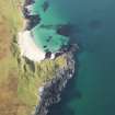
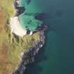
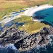
Location Notes: This is a rocky headland below the ruined chapel with extensive outcropping rock. The circular depressions are at the high tide mark and are all almost certainly bait holes, or toll sollaidh, used for grinding whelks, cockles, limpets, mussels, and other shell-fish before throwing them into the sea to attract fish.
They may be some of the bait holes referred to by Alexander Carmichael, writing on Carmina Gadelica ii, 361: 'The Lady Amie (14th century), wife of John, Lord of the Isles, sent men round the islands to make hollows in the rocks in which the people might break shell-fish and prepare bait. Such pits are called 'toll solaidh,' bait holes. These mortars resemble cup cuttings, for which antiquarians have mistaken them.' This information may derive from a document about Teampall Chà irinis in North Uist, recorded from John Mackinnon in 1871.

