
Following the launch of trove.scot in February 2025 we are now planning the retiral of some of our webservices. Canmore will be switched off on 24th June 2025. Information about the closure can be found on the HES website: Retiral of HES web services | Historic Environment Scotland
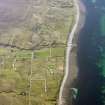
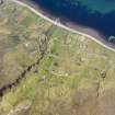
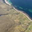
Melvaig, Aultgrishan


Field System (Period Unassigned), Lime Kiln (Period Unassigned), Township (Period Unassigned)
Site Name Melvaig, Aultgrishan
Classification Field System (Period Unassigned), Lime Kiln (Period Unassigned), Township (Period Unassigned)
Alternative Name(s) Altgreshan
Canmore ID 104961
Site Number NG78NW 5
NGR NG 742 858
NGR Description Centred NG 742 858
Datum OSGB36 - NGR
Permalink http://canmore.org.uk/site/104961


- Council Highland
- Parish Gairloch
- Former Region Highland
- Former District Ross And Cromarty
- Former County Ross And Cromarty
Note
A crofting township comprising fifty-six roofed, four partially roofed, sixteen unroofed buildings, their associated enclosures, a limekiln and a field-system is depicted on the 1st edition of the OS 6-inch map (Ross-shire 1881, sheet xxxi). Forty roofed, two partially roofed, fifty unroofed buildings and their associated enclosures are shown on the current edition of the OS 1:10560 map (1969).
Information from RCAHMS (SAH) 17 April 1996

